Marilyn · Skye & The Small Isles
Beinn a' Bhraghad
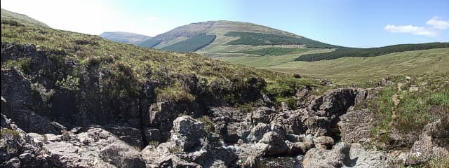
Beinn a' Bhraghad is a 461m grassy hill rising behind Sconser on Skye, looking across Loch Sligachan to the Red Hills. Its open ridge offers a quick escape with an easy summit and big views for relatively small effort.
Quick facts
- Height
- 461m/ 1512ft
- Prominence
- 276 m
- Grid ref
- NG 40976 25408
- Dogs
- Dogs on lead required near livestockDog-friendly guide ↗
Height and prominence cross-checked against the Database of British and Irish Hills (CC BY).
No GPX track yet
Walked this route? Share your track to help other walkers.
Standard route
heather moorland 55% · rocky slopes 30% · grass slopes 15%
Start from Sconser (golf course area) and climb the broad south-west flank on sheep tracks. About 5-6 km return with around 400m of ascent.
Terrain
Heather and bilberry on lower slopes giving way to short cropped grass on the upper ridge. Surprisingly dry underfoot for Skye.
In winter
Generally snow-free at this elevation but the ridge is fully exposed to gales sweeping in from the Sound of Raasay. Walking poles handy in winds.
Best time of year
Getting there
- Glasgow6h 23m
- Edinburgh9h 42m
OS maps: OS Landranger 32, OS Explorer 411
Mobile signal: Poor. Nothing dependable; EE gives out away from Broadford and Portree.
Current conditions
Daylight Today
- Sunrise
- 05:18
- Sunset
- 21:45
- Civil dawn
- 04:26
- Civil dusk
- 22:38
NOAA Solar Calculator · 30 July 2026
Around Beinn a' Bhraghad on the SCOT network
Getting there, basing yourself, and what to do off the hill.
Getting there: Kyle of Lochalsh station
Skye Bridge; Five Sisters of Kintail; Glen Shiel; Plockton
35km from the hill
tripscot.co.uk
On TripSCOTBase yourself in Portree
Main Skye base — Cuillin, Trotternish, Storr
20km from the hill
tripscot.co.uk
On TasteSCOTAfter the hill: Talisker
Carbost on Skye — Cuillin foothills distillery; peppery, maritime, big-bodied
7km from the hill
tastescot.co.uk
Beinn a' Bhraghad — common questions
- How difficult is Beinn a' Bhraghad?
- Beinn a' Bhraghad carries a 1/5 (easy) grade on the OutdoorSCOT scale. Terrain: Heather and bilberry on lower slopes giving way to short cropped grass on the upper ridge.
- How prominent is Beinn a' Bhraghad?
- Beinn a' Bhraghad has 276m of topographic prominence — the height of its summit above the highest col connecting it to higher ground. Marilyns are defined by that measure: at least 150m of drop on all sides.
- When should I climb Beinn a' Bhraghad?
- The standard good-weather months for Beinn a' Bhraghad are March, April, May, June, July, August, September, October. Outside those months, expect winter conditions on the high ground — full mountain kit, navigation skills, and a check of the SAIS avalanche forecast for the relevant region.
- Can I bring my dog up Beinn a' Bhraghad?
- On a lead only — the route crosses ground with livestock or nesting-bird interest.
- What's mobile reception like on Beinn a' Bhraghad?
- Poor. Nothing dependable; EE gives out away from Broadford and Portree.
- Is Beinn a' Bhraghad safe in winter?
- Generally snow-free at this elevation but the ridge is fully exposed to gales sweeping in from the Sound of Raasay. Walking poles handy in winds.
Get the OutdoorSCOT weekly
One email a week — new route, hill and bothy guides, seasonal conditions and the odd hard-won lesson. No spam, unsubscribe in one click.