Graham · Far North
Creag Mhor
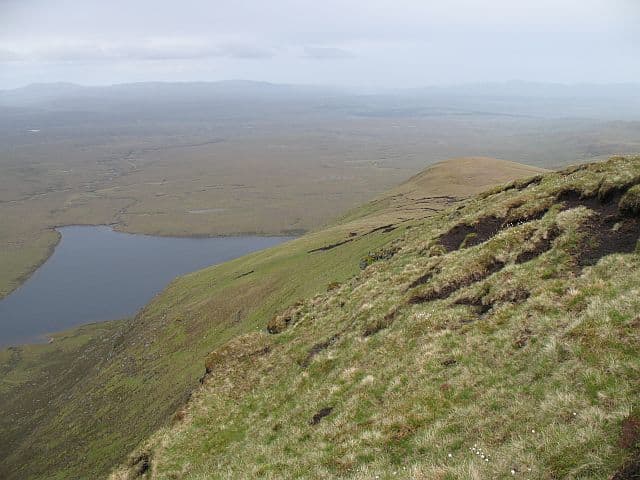
Creag Mhor (712m) — the big crag — stands at NC69 well into central Sutherland, a quartzite-and-gneiss summit lost among the lonely moors south-east of Ben Hope. With Strath More to the north and Loch Choire to the south, this is one of the more isolated Grahams in the country. The small cairn looks across an extraordinary emptiness toward Ben Klibreck and the Flow Country.
Gaelic: “crag, big” · Pronunciation: krayg vore
Quick facts
- Height
- 712.6m/ 2338ft
- Prominence
- 369 m
- Distance
- 13 km
- Ascent
- 584 m
- Time
- 4–6 hrs
- Grid ref
- NC698240
- Nearest
- Ullapool· Inverness 79km
- Dogs
- Dogs on lead required near livestockDog-friendly guide ↗
Height and prominence cross-checked against the Database of British and Irish Hills (CC BY).
No GPX track yet
Walked this route? Share your track to help other walkers.
Standard route
moorland path 20% · bog and heather 50% · grassy upper slopes 20% · summit area 10%
No conventional parking — the nearest road end is the public road to Altnaharra, with a long bike-and-walk in via the Loch Choire estate track. Allow a full day from the moment you leave tarmac. Stated distance of 13km represents the upland portion; the cycle approach adds considerably. 584m of ascent on the hill itself, much of it on uniform open moor.
Terrain
Sphagnum bog and deer-grass hummocks dominate the lower ground; expect to take twice the time of a Highland forest path. Above 500m the terrain firms onto stony moss with scattered quartzite blocks. The small summit cairn perches on a barely-defined high point — a GPS waypoint is genuinely useful.
In winter
Far-north Sutherland in winter is more about wind, wet snow and short days than about deep frozen pack. December daylight at this latitude is just over six hours of usable light. The SAIS Northern Highlands area is the nearest forecast and applies in spirit. Carry full storm-shell layers — there is no shelter for kilometres.
Best time of year
Getting there
- Glasgow5h 58m
- Edinburgh5h 55m
OS maps: OS Landranger 16, OS Explorer 443
Mobile signal: No reliable signal anywhere on the approach or summit
Current conditions
Daylight Today
- Sunrise
- 04:39
- Sunset
- 22:07
- Civil dawn
- 03:35
- Civil dusk
- 23:11
NOAA Solar Calculator · 17 July 2026
Around Creag Mhor on the SCOT network
Getting there, basing yourself, and what to do off the hill.
Getting there: Lairg station
Central Sutherland; Ben Klibreck approach; gateway to Far North inland
22km from the hill
tripscot.co.uk
On TripSCOTBase yourself in Durness
Cape Wrath base; Smoo Cave; Sandwood Bay walk-in
53km from the hill
tripscot.co.uk
On TasteSCOTAfter the hill: Clynelish
Brora — waxy, coastal-Highland classic on the Far North line
29km from the hill
tastescot.co.uk
Creag Mhor — common questions
- How hard is Creag Mhor?
- We grade Creag Mhor at 4/5, which puts it in challenging territory. The usual route is around 13km with 584m of climbing; allow 4-6 hours. Terrain: Sphagnum bog and deer-grass hummocks dominate the lower ground; expect to take twice the time of a Highland forest path.
- How prominent is Creag Mhor?
- Creag Mhor has 369m of topographic prominence — the height of its summit above the highest col connecting it to higher ground.
- When should I climb Creag Mhor?
- The standard good-weather months for Creag Mhor are May, June, July, August, September. Outside those months, expect winter conditions on the high ground — full mountain kit, navigation skills, and a check of the SAIS avalanche forecast for the relevant region.
- Can I bring my dog up Creag Mhor?
- On a lead only — the route crosses ground with livestock or nesting-bird interest.
- What's mobile reception like on Creag Mhor?
- No reliable signal anywhere on the approach or summit
- Is Creag Mhor safe in winter?
- Far-north Sutherland in winter is more about wind, wet snow and short days than about deep frozen pack. December daylight at this latitude is just over six hours of usable light. The SAIS Northern Highlands area is the nearest forecast and applies in spirit. Carry full storm-shell layers — there is no shelter for kilometres.
Get the OutdoorSCOT weekly
One email a week — new route, hill and bothy guides, seasonal conditions and the odd hard-won lesson. No spam, unsubscribe in one click.