Graham · Far North
Beinn Dhorain
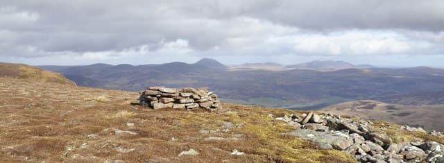
Beinn Dhorain (628m) is the eastern stronghold of the lonely Sutherland Grahams in the NC92 square, set back from the coast above the Strath of Kildonan. The cairn rises on a heathery dome looking down to the Helmsdale river and across the Flow Country to Morven of Caithness. Despite the apparently modest height the all-round emptiness gives the summit the feel of a far bigger hill.
Quick facts
- Height
- 628.3m/ 2061ft
- Prominence
- 416 m
- Distance
- 12 km
- Ascent
- 471 m
- Time
- 3–6 hrs
- Grid ref
- NC925156
- Parking
- NC920240
- Nearest city
- Inverness· 75km
- Dogs
- Dogs on lead required near livestockDog-friendly guide ↗
Height and prominence cross-checked against the Database of British and Irish Hills (CC BY).
No GPX track yet
Walked this route? Share your track to help other walkers.
Standard route
heather and bog 65% · grass slopes 25% · rocky summit 10%
Start from the small parking pull-in at NC920240 by the Kildonan road and follow the deer fence south-east before climbing onto the long northern shoulder. The going is firm at first then breaks into hags and peat pavement above 400m. The cairn is reached after a final pull onto the dome. Six to seven hours is realistic given the trackless approach and the distance from the parking spot.
Terrain
Wet heather and peat hags dominate the lower walk in, with bog-cotton meadows in summer. Higher up the ground firms into short heather and lichen-spotted moss. There are no paths and the only handrails are the deer fence and the watercourses falling east toward the Helmsdale.
In winter
Sutherland's east-coast Grahams catch driven snow from north-easterlies blowing in off the Moray Firth, and the broad dome of Beinn Dhorain drifts deeply on its lee. The Strath of Kildonan road may close briefly in bad weather. Daylight is short and a headtorch is essential for any winter attempt — the trackless return is much slower than the climb.
Best time of year
Getting there
- Glasgow5h 51m
- Edinburgh5h 41m
OS maps: OS Landranger 17
Mobile signal: Poor. Very remote Sutherland; intermittent coverage at best.
Current conditions
Daylight Today
- Sunrise
- 04:31
- Sunset
- 22:11
- Civil dawn
- 03:25
- Civil dusk
- 23:17
NOAA Solar Calculator · 13 July 2026
Around Beinn Dhorain on the SCOT network
Getting there, basing yourself, and what to do off the hill.
Beinn Dhorain — common questions
- How difficult is Beinn Dhorain?
- Beinn Dhorain carries a 4/5 (challenging) grade on the OutdoorSCOT scale. Count on about 12km, 471m of ascent and a 3-6 hour day on the standard route. Terrain: Wet heather and peat hags dominate the lower walk in, with bog-cotton meadows in summer.
- How prominent is Beinn Dhorain?
- Beinn Dhorain has 416m of topographic prominence — the height of its summit above the highest col connecting it to higher ground.
- Where should I park to climb Beinn Dhorain?
- Standard parking is at NC920240. Check the parking grid reference on an OS map before travel; informal laybys can fill on summer weekends.
- When should I climb Beinn Dhorain?
- The standard good-weather months for Beinn Dhorain are May, June, July, August, September. Outside those months, expect winter conditions on the high ground — full mountain kit, navigation skills, and a check of the SAIS avalanche forecast for the relevant region.
- Can I bring my dog up Beinn Dhorain?
- On a lead only — the route crosses ground with livestock or nesting-bird interest.
- What's mobile reception like on Beinn Dhorain?
- Poor. Very remote Sutherland; intermittent coverage at best.
- Is Beinn Dhorain safe in winter?
- Sutherland's east-coast Grahams catch driven snow from north-easterlies blowing in off the Moray Firth, and the broad dome of Beinn Dhorain drifts deeply on its lee. The Strath of Kildonan road may close briefly in bad weather. Daylight is short and a headtorch is essential for any winter attempt — the trackless return is much slower than the climb.
Get the OutdoorSCOT weekly
One email a week — new route, hill and bothy guides, seasonal conditions and the odd hard-won lesson. No spam, unsubscribe in one click.