Graham · Far North
Scaraben
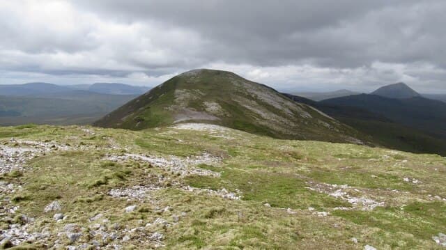
Scaraben (626m) is the high point of inland Caithness, set in the ND06 square between the Berriedale Water and the Langwell estate. A quartzite ridge punctuated by three knobbly tops gives the hill its bony profile, visible for miles as a pale ribbon above the Flow Country. The trig pillar in its small shelter sits on the central top, with views from Sutherland's east coast to the Pentland Firth.
Quick facts
- Height
- 626m/ 2054ft
- Prominence
- 331 m
- Distance
- 12 km
- Ascent
- 470 m
- Time
- 3–6 hrs
- Grid ref
- ND066268
- Parking
- ND016284
- Nearest city
- Inverness· 91km
- Dogs
- Dogs on lead required near livestockDog-friendly guide ↗
Height and prominence cross-checked against the Database of British and Irish Hills (CC BY).
No GPX track yet
Walked this route? Share your track to help other walkers.
Standard route
blanket bog 50% · heather moorland 35% · rocky summit 15%
From the layby at ND016284 on the Braemore road, follow the estate path east before climbing onto the western shoulder over peat. The ridge proper is gained at the first quartzite knob, and a clear scramble line links the three tops. Round trip about six hours; on the way down, drop south-west off the western top onto firmer ground to avoid the worst of the surrounding bog.
Terrain
The walk in crosses open peat with a scatter of bog pools — wet trousers are usual. The ridge itself is a delight, weathered quartzite blocks on a narrow crest with easy line choice between the tops. The drop to the trig's shelter cairn is short, with the steepest ground falling north into Lochan Coire na Saobhaidh.
In winter
Caithness gets less snow than the high mountains but Scaraben's exposed ridge ices up quickly under freezing fog driven in off the North Sea. The quartzite blocks become treacherous when glazed, and the wind chill on the open crest is severe. Daylight in midwinter dips below seven hours and an early start is essential.
Best time of year
Getting there
- Glasgow5h 6m
- Edinburgh5h 52m
OS maps: OS Landranger 17
Mobile signal: Poor. Very remote Caithness; just fragments of signal.
Current conditions
Daylight Today
- Sunrise
- 04:30
- Sunset
- 22:11
- Civil dawn
- 03:22
- Civil dusk
- 23:18
NOAA Solar Calculator · 13 July 2026
Around Scaraben on the SCOT network
Getting there, basing yourself, and what to do off the hill.
Scaraben — common questions
- Is Scaraben a hard climb?
- Scaraben is rated 4/5 (challenging) on the OutdoorSCOT scale. The standard route covers about 12km with 470m of ascent and takes most walkers 3-6 hours. Underfoot: The walk in crosses open peat with a scatter of bog pools — wet trousers are usual.
- What is Scaraben's prominence?
- 331m of prominence. That's the vertical drop from the summit to the col that links Scaraben to the next higher ground.
- Where do I park for Scaraben?
- Most walkers start from ND016284. Verify the grid reference on an OS map before you set off — space is tight on busy summer weekends.
- When is the best time to climb Scaraben?
- May, June, July, August, September give the most reliable conditions on Scaraben. Beyond that window the high ground turns wintry: carry full mountain kit, be confident navigating, and check the SAIS avalanche forecast for the area.
- Is Scaraben dog-friendly?
- Yes, but dogs must be kept on a lead — there is livestock or ground-nesting bird interest on the route.
- Is there mobile signal on Scaraben?
- Poor. Very remote Caithness; just fragments of signal.
- Is Scaraben safe in winter?
- Caithness gets less snow than the high mountains but Scaraben's exposed ridge ices up quickly under freezing fog driven in off the North Sea. The quartzite blocks become treacherous when glazed, and the wind chill on the open crest is severe. Daylight in midwinter dips below seven hours and an early start is essential.
Get the OutdoorSCOT weekly
One email a week — new route, hill and bothy guides, seasonal conditions and the odd hard-won lesson. No spam, unsubscribe in one click.