Donald · Borders
Molls Cleuch Dod
Molls Cleuch Dod is the quiet linking top between Lochcraig Head and Firthybrig on the inner Moffat watershed. A modest cairn sits beside the old march wall that runs east into the headwaters of the Talla Water. It sees a fraction of the visitors that pass through, despite being entirely on the way.
Quick facts
- Height
- 785m/ 2575ft
- Prominence
- 39 m
- Distance
- 14 km
- Ascent
- 644 m
- Time
- 4–7 hrs
- Grid ref
- NT151179
- Parking
- NT156173
- Nearest city
- Dumfries· 45km
- Dogs
- Dogs on lead required near livestockDog-friendly guide ↗
Height and prominence cross-checked against the Database of British and Irish Hills (CC BY).
No GPX track yet
Walked this route? Share your track to help other walkers.
Standard route
grass moorland 80% · heather patches 15% · summit area 5%
Most pick it up as part of a White Coomb–Lochcraig Head round from the Grey Mare's Tail. A more solitary alternative comes up the Cleuch itself from Talla Reservoir, climbing rough grass slopes onto the col.
Terrain
Cropped sheep pasture and pale moss over the whole watershed; the old wall offers a continuous handrail. Spongy ground in hollows but generally drier than the Galloway hills.
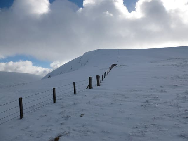
In winter
Wind-scoured in midwinter — often more ice than snow on the wall stones. The wide col can hold drifts that disguise the line of the wall. Pop a torch in the sack; the days are short.
Best time of year
Getting there
- Glasgow2h 44m
- Edinburgh1h 21m
OS maps: OS Landranger 79
Mobile signal: Solid summit coverage; EE behaves well. Southern Uplands watershed viewpoint.
Current conditions
Daylight Today
- Sunrise
- 04:54
- Sunset
- 21:45
- Civil dawn
- 04:01
- Civil dusk
- 22:38
NOAA Solar Calculator · 17 July 2026
Around Molls Cleuch Dod on the SCOT network
Getting there, basing yourself, and what to do off the hill.
Molls Cleuch Dod — common questions
- What difficulty is Molls Cleuch Dod?
- On the OutdoorSCOT scale, Molls Cleuch Dod comes in at 4/5 — challenging. Expect roughly 14km and 644m of ascent on the usual route — 4-7 hours for most parties. Ground conditions: Cropped sheep pasture and pale moss over the whole watershed; the old wall offers a continuous handrail.
- How much drop does Molls Cleuch Dod have?
- The drop is 39m: measured from the summit of Molls Cleuch Dod down to the saddle joining it to higher terrain.
- Where's the parking for Molls Cleuch Dod?
- Park at NT156173. Double-check the grid reference on an OS map first; informal laybys here fill early in high season.
- What's the best month to climb Molls Cleuch Dod?
- Aim for April, May, June, July, August, September, October on Molls Cleuch Dod. In the remaining months treat it as a winter hill — full kit, solid navigation, and a look at the relevant SAIS avalanche forecast before you go.
- Can dogs go up Molls Cleuch Dod?
- Dogs are fine on a lead. The route passes livestock or ground-nesting bird habitat, so keep them close throughout.
- Will I get phone signal on Molls Cleuch Dod?
- Solid summit coverage; EE behaves well. Southern Uplands watershed viewpoint.
- Is Molls Cleuch Dod safe in winter?
- Wind-scoured in midwinter — often more ice than snow on the wall stones. The wide col can hold drifts that disguise the line of the wall. Pop a torch in the sack; the days are short.
Get the OutdoorSCOT weekly
One email a week — new route, hill and bothy guides, seasonal conditions and the odd hard-won lesson. No spam, unsubscribe in one click.