Donald · Borders
Lochcraig Head
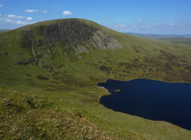
Lochcraig Head stands directly above the dark waters of Loch Skeen, its craggy north-east face plunging straight down to the loch in one of the finest scenes of the Southern Uplands. From the small summit cairn the eye is drawn down to White Coomb and the cleft of the Grey Mare's Tail.
Quick facts
- Height
- 800.8m/ 2627ft
- Prominence
- 108 m
- Distance
- 14 km
- Ascent
- 656 m
- Time
- 4–7 hrs
- Grid ref
- NT166177
- Parking
- NT161172
- Nearest city
- Dumfries· 46km
- Dogs
- Dogs on lead required near livestockDog-friendly guide ↗
Height and prominence cross-checked against the Database of British and Irish Hills (CC BY).
No GPX track yet
Walked this route? Share your track to help other walkers.
Standard route
grass moorland 70% · heather slopes 20% · rocky outcrops 10%
Park at the NTS Tail Burn lay-by and take the path past the waterfall and Loch Skeen, then climb the steep rim onto the plateau. A simple horseshoe with White Coomb and Firthhope Rig back to the burn makes a memorable day.
Terrain
A well-defined path runs from the Tail Burn car park as far as Loch Skeen. Above that it is mostly trackless steep grass, with the crag edge clipping close to the summit — keep a respectful distance in poor visibility.
In winter
Cornices form readily along the rim above Loch Skeen and have given way more than once over the years; treat the edge as untouchable in snow. SAIS Southern Uplands forecasts the corries on the Moffat front face directly.
Best time of year
Getting there
- Glasgow2h 46m
- Edinburgh1h 21m
OS maps: OS Landranger 79
Mobile signal: Good summit signal; EE reliable with views over the Moffat Hills.
Current conditions
Daylight Today
- Sunrise
- 04:54
- Sunset
- 21:44
- Civil dawn
- 04:01
- Civil dusk
- 22:38
NOAA Solar Calculator · 17 July 2026
Around Lochcraig Head on the SCOT network
Getting there, basing yourself, and what to do off the hill.
Lochcraig Head — common questions
- Is Lochcraig Head a hard climb?
- Lochcraig Head is rated 4/5 (challenging) on the OutdoorSCOT scale. The standard route covers about 14km with 656m of ascent and takes most walkers 4-7 hours. Terrain: A well-defined path runs from the Tail Burn car park as far as Loch Skeen.
- How prominent is Lochcraig Head?
- Lochcraig Head has 108m of topographic prominence — the height of its summit above the highest col connecting it to higher ground.
- Where should I park to climb Lochcraig Head?
- Standard parking is at NT161172. Check the parking grid reference on an OS map before travel; informal laybys can fill on summer weekends.
- When should I climb Lochcraig Head?
- The standard good-weather months for Lochcraig Head are April, May, June, July, August, September, October. Outside those months, expect winter conditions on the high ground — full mountain kit, navigation skills, and a check of the SAIS avalanche forecast for the relevant region.
- Can I bring my dog up Lochcraig Head?
- On a lead only — the route crosses ground with livestock or nesting-bird interest.
- What's mobile reception like on Lochcraig Head?
- Good summit signal; EE reliable with views over the Moffat Hills.
- Is Lochcraig Head safe in winter?
- Cornices form readily along the rim above Loch Skeen and have given way more than once over the years; treat the edge as untouchable in snow. SAIS Southern Uplands forecasts the corries on the Moffat front face directly.
Get the OutdoorSCOT weekly
One email a week — new route, hill and bothy guides, seasonal conditions and the odd hard-won lesson. No spam, unsubscribe in one click.