Donald · Borders
Herman Law
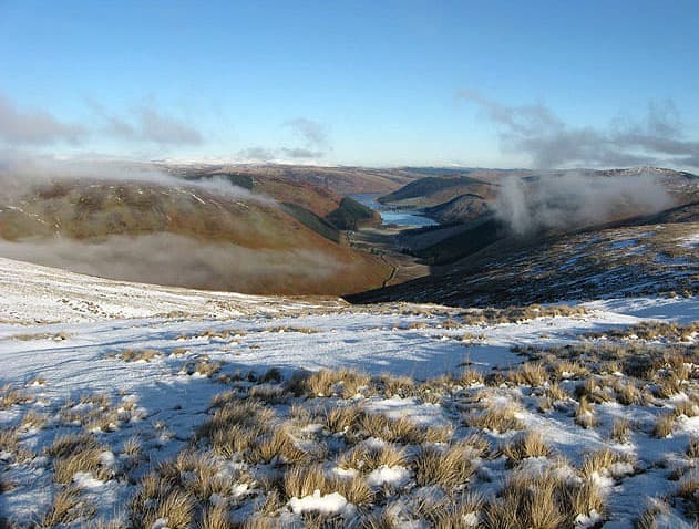
Herman Law (614m) is the eastern bookend of the Ettrick Hills, a quiet grassy top above the headwaters of the Tima Water. A fence junction marks the summit. The hill is rarely climbed by itself — most parties take it in on a long traverse from Bell Craig through Andrewhinney Hill, or from the Ettrick valley as part of the watershed round. The views east over the Yarrow toward St Mary's Loch are the highlight.
Quick facts
- Height
- 614.4m/ 2016ft
- Prominence
- 31 m
- Distance
- 12 km
- Ascent
- 460 m
- Time
- 3–5 hrs
- Grid ref
- NT213156
- Parking
- NT212153
- Nearest city
- Dumfries· 46km
- Dogs
- Dogs on lead required near livestockDog-friendly guide ↗
Height and prominence cross-checked against the Database of British and Irish Hills (CC BY).
No GPX track yet
Walked this route? Share your track to help other walkers.
Standard route
grass moorland 80% · heather patches 15% · summit area 5%
A useful starting point is the road end at the head of the Tima Water (NT212153 area, on the Ettrick–Yarrow back road), from where a fence climbs directly to the summit junction in 12km with 460m of ascent. The going is open hill pasture and short heather, with the fence as a continuous handrail. Many parties extend along the watershed to Trowgrain Middle and Andrewhinney for a longer ridge.
Terrain
Pastoral grass and shallow tussock characterise the lower slopes; the watershed rolls broadly with peat hags between the higher tops. The fence line that meets at the summit junction provides reliable navigation, and the open ground is accessible year-round. The Ettrick side falls more steeply than the Yarrow side and cleuchs make poor descent lines.
In winter
The eastern Ettrick Hills catch the full force of easterly haar and northerly continentals — Herman Law's broad top becomes a featureless white plateau in poor weather, with only the fence to fix a position on. Cornices form along the steep northern edges into Tima Burn. SAIS Southern Uplands bulletins cover this ground when warranted; visibility is the constant challenge.
Best time of year
Getting there
- Glasgow2h 53m
- Edinburgh1h 23m
OS maps: OS Landranger 79
Mobile signal: Good summit signal; EE is dependable. Fine Yarrow Water viewpoint.
Current conditions
Daylight Today
- Sunrise
- 04:48
- Sunset
- 21:49
- Civil dawn
- 03:54
- Civil dusk
- 22:44
NOAA Solar Calculator · 13 July 2026
Around Herman Law on the SCOT network
Getting there, basing yourself, and what to do off the hill.
Herman Law — common questions
- What difficulty is Herman Law?
- On the OutdoorSCOT scale, Herman Law comes in at 3/5 — moderately challenging. Expect roughly 12km and 460m of ascent on the usual route — 3-5 hours for most parties. Underfoot: Pastoral grass and shallow tussock characterise the lower slopes; the watershed rolls broadly with peat hags between the higher tops.
- What is Herman Law's prominence?
- 31m of prominence. That's the vertical drop from the summit to the col that links Herman Law to the next higher ground.
- Where do I park for Herman Law?
- Most walkers start from NT212153. Verify the grid reference on an OS map before you set off — space is tight on busy summer weekends.
- When is the best time to climb Herman Law?
- March, April, May, June, July, August, September, October, November give the most reliable conditions on Herman Law. Beyond that window the high ground turns wintry: carry full mountain kit, be confident navigating, and check the SAIS avalanche forecast for the area.
- Is Herman Law dog-friendly?
- Yes, but dogs must be kept on a lead — there is livestock or ground-nesting bird interest on the route.
- Is there mobile signal on Herman Law?
- Good summit signal; EE is dependable. Fine Yarrow Water viewpoint.
- Is Herman Law safe in winter?
- The eastern Ettrick Hills catch the full force of easterly haar and northerly continentals — Herman Law's broad top becomes a featureless white plateau in poor weather, with only the fence to fix a position on. Cornices form along the steep northern edges into Tima Burn. SAIS Southern Uplands bulletins cover this ground when warranted; visibility is the constant challenge.
Get the OutdoorSCOT weekly
One email a week — new route, hill and bothy guides, seasonal conditions and the odd hard-won lesson. No spam, unsubscribe in one click.