Donald · Borders
Bell Craig
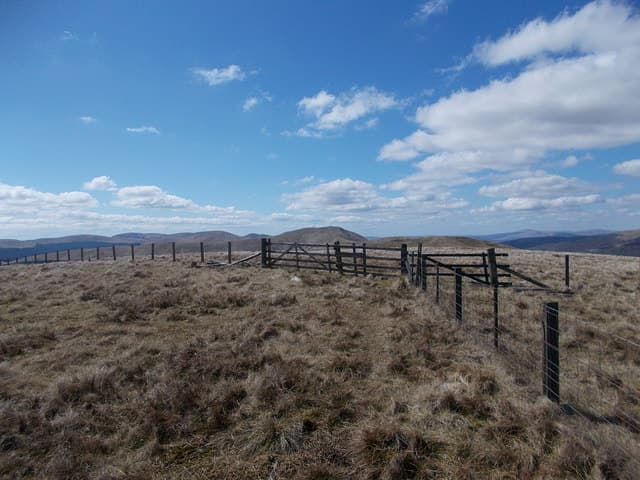
Bell Craig (623m) sits between Loch of the Lowes and the upper Ettrick, a rolling green top on the long watershed dividing Yarrow from Moffat Water. The summit is marked only by a fence junction — the high point lies a couple of metres east of the corner. Bell Craig joins Capel Fell and Andrewhinney Hill in a series of paired summits that ring the Loch Skeen amphitheatre to the west.
Quick facts
- Height
- 623m/ 2044ft
- Prominence
- 47 m
- Distance
- 12 km
- Ascent
- 467 m
- Time
- 3–5 hrs
- Grid ref
- NT186128
- Parking
- NT187143
- Nearest city
- Dumfries· 42km
- Dogs
- Dogs on lead required near livestockDog-friendly guide ↗
Height and prominence cross-checked against the Database of British and Irish Hills (CC BY).
No GPX track yet
Walked this route? Share your track to help other walkers.
Standard route
grass moorland 80% · heather patches 15% · summit area 5%
A good approach starts from the Tail Burn car park at the Grey Mare's Tail (NT187143) and climbs by way of the path to Loch Skeen before peeling east up the steep grassy face of Andrewhinney and following the watershed fence south to Bell Craig — 12km with 467m of ascent. The fence makes the navigation simple once gained. Return is best by retracing rather than dropping into the steep cleuchs of Selcoth.
Terrain
The classic Moffat Hills mix — cropped grass underfoot, peat hags where the watershed broadens, and steep drops into the surrounding cleuchs. The watershed fence is the dominant navigational feature for most of the day. Loch Skeen lies in a hidden hollow below and is worth a detour on the return leg if time allows.
In winter
These hills sit at the meteorological heart of the Southern Uplands and feel high in winter — Loch Skeen freezes solid in cold spells and the Grey Mare's Tail forms substantial ice every few years. Bell Craig's grassy summit ices to nevé; the watershed fence is a lifeline in driven snow. Check SAIS Southern Uplands before any winter visit.
Best time of year
Getting there
- Glasgow2h 53m
- Edinburgh1h 28m
OS maps: OS Landranger 79
Mobile signal: Good signal throughout; EE seldom drops. Fine views to the Borders.
Current conditions
Daylight Today
- Sunrise
- 04:49
- Sunset
- 21:49
- Civil dawn
- 03:54
- Civil dusk
- 22:44
NOAA Solar Calculator · 13 July 2026
Around Bell Craig on the SCOT network
Getting there, basing yourself, and what to do off the hill.
Bell Craig — common questions
- What difficulty is Bell Craig?
- On the OutdoorSCOT scale, Bell Craig comes in at 3/5 — moderately challenging. Expect roughly 12km and 467m of ascent on the usual route — 3-5 hours for most parties. Ground conditions: The classic Moffat Hills mix — cropped grass underfoot, peat hags where the watershed broadens, and steep drops into the surrounding cleuchs.
- How much drop does Bell Craig have?
- The drop is 47m: measured from the summit of Bell Craig down to the saddle joining it to higher terrain.
- Where's the parking for Bell Craig?
- Park at NT187143. Double-check the grid reference on an OS map first; informal laybys here fill early in high season.
- What's the best month to climb Bell Craig?
- Aim for March, April, May, June, July, August, September, October, November on Bell Craig. In the remaining months treat it as a winter hill — full kit, solid navigation, and a look at the relevant SAIS avalanche forecast before you go.
- Can dogs go up Bell Craig?
- Dogs are fine on a lead. The route passes livestock or ground-nesting bird habitat, so keep them close throughout.
- Will I get phone signal on Bell Craig?
- Good signal throughout; EE seldom drops. Fine views to the Borders.
- Is Bell Craig safe in winter?
- These hills sit at the meteorological heart of the Southern Uplands and feel high in winter — Loch Skeen freezes solid in cold spells and the Grey Mare's Tail forms substantial ice every few years. Bell Craig's grassy summit ices to nevé; the watershed fence is a lifeline in driven snow. Check SAIS Southern Uplands before any winter visit.
Get the OutdoorSCOT weekly
One email a week — new route, hill and bothy guides, seasonal conditions and the odd hard-won lesson. No spam, unsubscribe in one click.