Donald · Borders
Bodesbeck Law
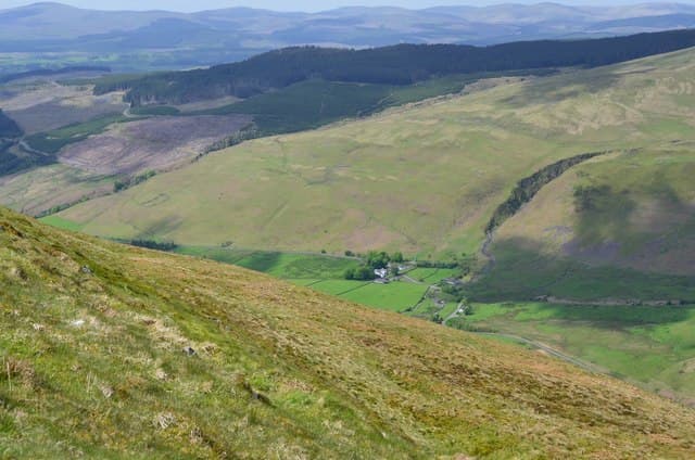
Bodesbeck Law forms the southern bookend of the long Bodesbeck Ridge above the Moffat Water. A small cairn sits on a rocky knot at the southern tip of the ridge, with a dramatic drop into the Selcoth Burn glen at your feet.
Quick facts
- Height
- 664.2m/ 2179ft
- Prominence
- 101 m
- Distance
- 13 km
- Ascent
- 544 m
- Time
- 3–6 hrs
- Grid ref
- NT169104
- Parking
- NT181125
- Nearest city
- Dumfries· 39km
- Dogs
- Dogs on lead required near livestockDog-friendly guide ↗
Height and prominence cross-checked against the Database of British and Irish Hills (CC BY).
No GPX track yet
Walked this route? Share your track to help other walkers.
Standard route
grass moorland 80% · heather patches 15% · summit area 5%
From the A708 at Capplegill, climb steeply onto the ridge and follow it north to the cairn — a full traverse to Andrewhinney is around 14km with 850m of climb.
Terrain
Steep grass face onto the ridge, then a fine narrow watershed of cropped turf. A faint path runs the spine.
In winter
Cornices form on the east-facing edge above Selcoth Burn — verified by SAIS Southern Uplands reports in big winters. Stick to the windward side of the ridge.
Best time of year
Getting there
- Glasgow2h 54m
- Edinburgh2h 32m
OS maps: OS Landranger 79
Mobile signal: Good summit signal; EE works well. Southern Uplands moorland summit.
Current conditions
Daylight Today
- Sunrise
- 04:49
- Sunset
- 21:49
- Civil dawn
- 03:54
- Civil dusk
- 22:44
NOAA Solar Calculator · 13 July 2026
Around Bodesbeck Law on the SCOT network
Getting there, basing yourself, and what to do off the hill.
Bodesbeck Law — common questions
- Is Bodesbeck Law a hard climb?
- Bodesbeck Law is rated 3/5 (moderately challenging) on the OutdoorSCOT scale. The standard route covers about 13km with 544m of ascent and takes most walkers 3-6 hours. Ground conditions: Steep grass face onto the ridge, then a fine narrow watershed of cropped turf.
- How much drop does Bodesbeck Law have?
- The drop is 101m: measured from the summit of Bodesbeck Law down to the saddle joining it to higher terrain.
- Where's the parking for Bodesbeck Law?
- Park at NT181125. Double-check the grid reference on an OS map first; informal laybys here fill early in high season.
- What's the best month to climb Bodesbeck Law?
- Aim for March, April, May, June, July, August, September, October, November on Bodesbeck Law. In the remaining months treat it as a winter hill — full kit, solid navigation, and a look at the relevant SAIS avalanche forecast before you go.
- Can dogs go up Bodesbeck Law?
- Dogs are fine on a lead. The route passes livestock or ground-nesting bird habitat, so keep them close throughout.
- Will I get phone signal on Bodesbeck Law?
- Good summit signal; EE works well. Southern Uplands moorland summit.
- Is Bodesbeck Law safe in winter?
- Cornices form on the east-facing edge above Selcoth Burn — verified by SAIS Southern Uplands reports in big winters. Stick to the windward side of the ridge.
Get the OutdoorSCOT weekly
One email a week — new route, hill and bothy guides, seasonal conditions and the odd hard-won lesson. No spam, unsubscribe in one click.