Donald · Southern Uplands
Earncraig Hill
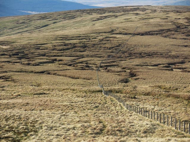
Earncraig Hill (611m) is a green dome at the eastern end of the Lowther Hills group, looking down on the Roman fort of Durisdeer and the old drove road over the Well Path. The summit is unusual — an embedded rock beside a march wall and a bend in the fence, three features converging on a small patch of ground. The view stretches from the Solway across to the Tweedsmuir massif and back along the Lowther ridge to the radar dome.
Quick facts
- Height
- 611m/ 2005ft
- Prominence
- 109 m
- Distance
- 12 km
- Ascent
- 458 m
- Time
- 3–5 hrs
- Grid ref
- NS973013
- Parking
- NS894039
- Nearest city
- Dumfries· 25km
- Dogs
- Dogs on lead required near livestockDog-friendly guide ↗
Height and prominence cross-checked against the Database of British and Irish Hills (CC BY).
No GPX track yet
Walked this route? Share your track to help other walkers.
Standard route
grass moorland 80% · heather patches 15% · summit area 5%
Park at Durisdeer village (NS894039) and walk up the Well Path drove road into the hills before climbing the steep grassy face of Earncraig's north-west ridge — 12km with 458m of ascent. The old drove road is a fine historical approach; the upper hill is path-free on cropped pasture. The Roman camp at Durisdeer is worth a circuit on the return leg. Many parties combine with Glenleith Fell.
Terrain
Classic Lowther sheep-cropped pasture from valley floor to summit dome, with the Well Path drove road providing a graded line up into the hills. Stone walls and ancient fences criss-cross the slopes and serve as both navigational aids and signs of centuries of pastoral history. The summit point requires a careful eye to identify among the converging features.
In winter
The Well Path is one of the historically snowed-in routes of the Southern Uplands — driving cattle in winter through here was a feat of endurance. Earncraig's grassy face freezes to hard nevé and the summit fence is the only reliable feature in cloud. Easterly winds funnel down from the Lowther radar ridge and chill the open pasture savagely.
Best time of year
Getting there
- Glasgow2h 46m
- Edinburgh2h 51m
OS maps: OS Landranger 78
Mobile signal: Coverage is solid; count on EE. Fine views toward the Borders.
Current conditions
Daylight Today
- Sunrise
- 04:51
- Sunset
- 21:50
- Civil dawn
- 03:56
- Civil dusk
- 22:44
NOAA Solar Calculator · 13 July 2026
Around Earncraig Hill on the SCOT network
Getting there, basing yourself, and what to do off the hill.
Earncraig Hill — common questions
- What difficulty is Earncraig Hill?
- On the OutdoorSCOT scale, Earncraig Hill comes in at 3/5 — moderately challenging. Expect roughly 12km and 458m of ascent on the usual route — 3-5 hours for most parties. Terrain: Classic Lowther sheep-cropped pasture from valley floor to summit dome, with the Well Path drove road providing a graded line up into the hills.
- How prominent is Earncraig Hill?
- Earncraig Hill has 109m of topographic prominence — the height of its summit above the highest col connecting it to higher ground.
- Where should I park to climb Earncraig Hill?
- Standard parking is at NS894039. Check the parking grid reference on an OS map before travel; informal laybys can fill on summer weekends.
- When should I climb Earncraig Hill?
- The standard good-weather months for Earncraig Hill are March, April, May, June, July, August, September, October, November. Outside those months, expect winter conditions on the high ground — full mountain kit, navigation skills, and a check of the SAIS avalanche forecast for the relevant region.
- Can I bring my dog up Earncraig Hill?
- On a lead only — the route crosses ground with livestock or nesting-bird interest.
- What's mobile reception like on Earncraig Hill?
- Coverage is solid; count on EE. Fine views toward the Borders.
- Is Earncraig Hill safe in winter?
- The Well Path is one of the historically snowed-in routes of the Southern Uplands — driving cattle in winter through here was a feat of endurance. Earncraig's grassy face freezes to hard nevé and the summit fence is the only reliable feature in cloud. Easterly winds funnel down from the Lowther radar ridge and chill the open pasture savagely.
Get the OutdoorSCOT weekly
One email a week — new route, hill and bothy guides, seasonal conditions and the odd hard-won lesson. No spam, unsubscribe in one click.