Donald · Central Belt
Beinn nan Eun
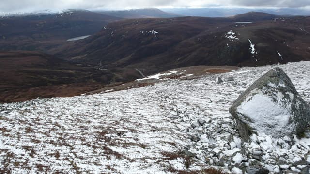
Beinn nan Eun (631m) — the hill of the birds — is a rolling moorland top above Glen Lednock north of Comrie, where the Highland Boundary Fault throws up its first serious peaks. The summit is unmarked among a wide spread of flat heather; the trig column for Auchnafree Hill lies further north. Beinn nan Eun looks out across Loch Earn to the Trossachs and up to the Ben Chonzie massif.
Quick facts
- Height
- 631m/ 2070ft
- Prominence
- 142 m
- Distance
- 12 km
- Ascent
- 473 m
- Time
- 3–5 hrs
- Grid ref
- NN723131
- Parking
- NN707118
- Nearest
- Stirling· Stirling 21km
- Dogs
- Dogs on lead required near livestockDog-friendly guide ↗
Height and prominence cross-checked against the Database of British and Irish Hills (CC BY).
No GPX track yet
Walked this route? Share your track to help other walkers.
Standard route
heather and bog 65% · grass slopes 25% · rocky summit 10%
Start from the Invergeldie road end above Glen Lednock at NN743271 and follow the estate track south-west onto open moorland before climbing the broad east shoulder. The walk covers 12km with 473m of ascent. The estate track does the lower work but the summit dome is heather and bog, with no clear path. A compass bearing is needed to locate the true high point among the rolling tussocks.
Terrain
Long heather and deep peat hags dominate the upper hill — the kind of ground that doubles walking times in poor conditions. The estate track from Invergeldie is well maintained as far as the foot of the slope, but above that progress is slow over hag-broken moor. Grouse butts dot the eastern flank and provide useful landmarks.
In winter
This Highland-edge ground catches Atlantic snowfall and the broad flat top can be a wilderness of drifted hags and frozen sphagnum. The heather is unkind to crampons but provides some grip when verglas coats the peat. Visibility drops fast off Glen Lednock and the lack of summit features makes whiteout navigation onerous — bearings off the estate track are essential.
Best time of year
Getting there
- Glasgow1h 11m
- Edinburgh2h 34m
OS maps: OS Landranger 57
Mobile signal: Expect little. Remote central Argyll; coverage here is marginal.
Current conditions
Daylight Today
- Sunrise
- 04:46
- Sunset
- 21:58
- Civil dawn
- 03:48
- Civil dusk
- 22:56
NOAA Solar Calculator · 13 July 2026
Around Beinn nan Eun on the SCOT network
Getting there, basing yourself, and what to do off the hill.
Getting there: Dunblane station
Stirling-area; Sheriffmuir; gateway north
14km from the hill
tripscot.co.uk
On TripSCOTBase yourself in Callander
Trossachs gateway — Ben Ledi, Stuc a Chroin, Rob Roy Way
11km from the hill
tripscot.co.uk
On TasteSCOTAfter the hill: Deanston
Doune — converted cotton mill; floral, honeyed Perthshire distillery
13km from the hill
tastescot.co.uk
Beinn nan Eun — common questions
- How hard is Beinn nan Eun?
- We grade Beinn nan Eun at 3/5, which puts it in moderately challenging territory. The usual route is around 12km with 473m of climbing; allow 3-5 hours. Ground conditions: Long heather and deep peat hags dominate the upper hill — the kind of ground that doubles walking times in poor conditions.
- How much drop does Beinn nan Eun have?
- The drop is 142m: measured from the summit of Beinn nan Eun down to the saddle joining it to higher terrain.
- Where's the parking for Beinn nan Eun?
- Park at NN707118 near Stirling. Double-check the grid reference on an OS map first; informal laybys here fill early in high season.
- What's the best month to climb Beinn nan Eun?
- Aim for March, April, May, June, July, August, September, October, November on Beinn nan Eun. In the remaining months treat it as a winter hill — full kit, solid navigation, and a look at the relevant SAIS avalanche forecast before you go.
- Can dogs go up Beinn nan Eun?
- Dogs are fine on a lead. The route passes livestock or ground-nesting bird habitat, so keep them close throughout.
- Will I get phone signal on Beinn nan Eun?
- Expect little. Remote central Argyll; coverage here is marginal.
- Is Beinn nan Eun safe in winter?
- This Highland-edge ground catches Atlantic snowfall and the broad flat top can be a wilderness of drifted hags and frozen sphagnum. The heather is unkind to crampons but provides some grip when verglas coats the peat. Visibility drops fast off Glen Lednock and the lack of summit features makes whiteout navigation onerous — bearings off the estate track are essential.
Get the OutdoorSCOT weekly
One email a week — new route, hill and bothy guides, seasonal conditions and the odd hard-won lesson. No spam, unsubscribe in one click.