Munro · Cairngorms
Beinn a' Bhuird (Beinn a' Bhuird North Top)
Beinn a' Bhuird — "the table mountain", from the broad table-flat top — is a 1197m Munro in the eastern Cairngorms between Glen Avon and Glen Quoich. The summit (North Top) sits on a vast granite plateau dotted with arctic-alpine vegetation, ringed on its east side by a continuous arc of cliffs above the Slochd Mor and the great corries of An Diollaid and Coire na Ciche. The hill is one of the least-visited of the high Cairngorms because of its sheer distance from any road; most parties walk in 18-22km each way.
Quick facts
- Height
- 1196m/ 3924ft
- Prominence
- 456 m
- Distance
- 19 km
- Ascent
- 1052 m
- Time
- 6–9 hrs
- Grid ref
- NJ092006
- Parking
- NO117910
- Nearest city
- Inverness· 62km
- Dogs
- Dogs on lead required near livestockDog-friendly guide ↗
Height and prominence cross-checked against the Database of British and Irish Hills (CC BY).
No GPX track yet
Walked this route? Share your track to help other walkers.
Standard route
Estate track / moorland 45% · Mountain path 25% · Plateau / boulder field 30%
The classic line is from Linn of Quoich on the Invercauld estate east of Braemar, taking the Glen Quoich track north for around 8km then climbing onto the Sneck plateau and following the broad ridge north over the Cnap a' Chleirich to the table-top summit. Around 28km return with 1052m of ascent — bike strongly recommended for the long Glen Quoich track. Often combined with Ben Avon for a two-Munro big day from the same start.
Terrain
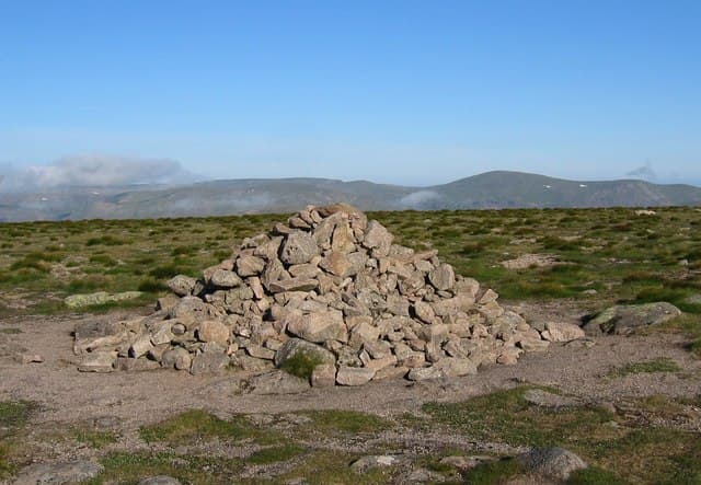
The Glen Quoich estate track is firm gravel — bike-friendly. The climb onto the Sneck is on rough heather and granite gravel; the plateau itself is short moss-and-stone arctic ground. The summit cairn is a small unmissable pile of blocks on a featureless plateau. The east-side corries are unfenced and undercut — keep west of the marked summit in mist.
In winter
A serious winter proposition. The east-facing cliffs of Coire na Ciche hold Grade III-V winter climbs. The plateau is a true arctic environment with sustained cornice formation and frequent whiteouts. The Glen Quoich track is generally followable under snow but the upper climb becomes a major navigational exercise. SAIS Northern Cairngorms applies.
This hill is in the Northern Cairngorms SAIS forecast area. Check SAIS forecasts in winter (December–April).
Best time of year
Getting there
- Glasgow3h 4m
- Edinburgh3h 43m
OS maps: OS Landranger 36
Mobile signal: No coverage on approach or top. The nearest reliable signal is at Braemar (8km south). Download maps offline well in advance.
Current conditions
Daylight Today
- Sunrise
- 05:59
- Sunset
- 20:34
- Civil dawn
- 05:16
- Civil dusk
- 21:17
NOAA Solar Calculator · 24 August 2026
Pair with
Curated multi-hill combinations from Beinn a' Bhuird (Beinn a' Bhuird North Top).
Got a photo of Beinn a' Bhuird (Beinn a' Bhuird North Top)?
30 seconds, helps other walkers.
Submit a photoAround Beinn a' Bhuird (Beinn a' Bhuird North Top) on the SCOT network
Getting there, basing yourself, and what to do off the hill.
Getting there: Aviemore station
Cairngorm plateau; Lairig Ghru; Speyside Way; Glenmore
23km from the hill
tripscot.co.uk
On TripSCOTBase yourself in Aviemore
Cairngorms base — Strathspey valley, ski centre, train
23km from the hill
tripscot.co.uk
On TasteSCOTAfter the hill: Tomintoul
Tomintoul village — the gentle Speysider in the eastern Cairngorms
19km from the hill
tastescot.co.uk
Beinn a' Bhuird (Beinn a' Bhuird North Top) — common questions
- How hard is Beinn a' Bhuird (Beinn a' Bhuird North Top)?
- We grade Beinn a' Bhuird (Beinn a' Bhuird North Top) at 4/5, which puts it in challenging territory. The usual route is around 19km with 1052m of climbing; allow 6-9 hours. Terrain: The Glen Quoich estate track is firm gravel — bike-friendly.
- How prominent is Beinn a' Bhuird (Beinn a' Bhuird North Top)?
- Beinn a' Bhuird (Beinn a' Bhuird North Top) has 456m of topographic prominence — the height of its summit above the highest col connecting it to higher ground.
- Where should I park to climb Beinn a' Bhuird (Beinn a' Bhuird North Top)?
- Standard parking is at NO117910. Check the parking grid reference on an OS map before travel; informal laybys can fill on summer weekends.
- When should I climb Beinn a' Bhuird (Beinn a' Bhuird North Top)?
- The standard good-weather months for Beinn a' Bhuird (Beinn a' Bhuird North Top) are May, June, July, August, September, October. Outside those months, expect winter conditions on the high ground — full mountain kit, navigation skills, and a check of the SAIS avalanche forecast for the relevant region.
- Can I bring my dog up Beinn a' Bhuird (Beinn a' Bhuird North Top)?
- On a lead only — the route crosses ground with livestock or nesting-bird interest.
- What's mobile reception like on Beinn a' Bhuird (Beinn a' Bhuird North Top)?
- No coverage on approach or top. The nearest reliable signal is at Braemar (8km south). Download maps offline well in advance.
- Is Beinn a' Bhuird (Beinn a' Bhuird North Top) safe in winter?
- A serious winter proposition. The east-facing cliffs of Coire na Ciche hold Grade III-V winter climbs. The plateau is a true arctic environment with sustained cornice formation and frequent whiteouts. The Glen Quoich track is generally followable under snow but the upper climb becomes a major navigational exercise. SAIS Northern Cairngorms applies.
Get the OutdoorSCOT weekly
One email a week — new route, hill and bothy guides, seasonal conditions and the odd hard-won lesson. No spam, unsubscribe in one click.