Sub-Marilyn · Cairngorms
Glas Mheall Mor
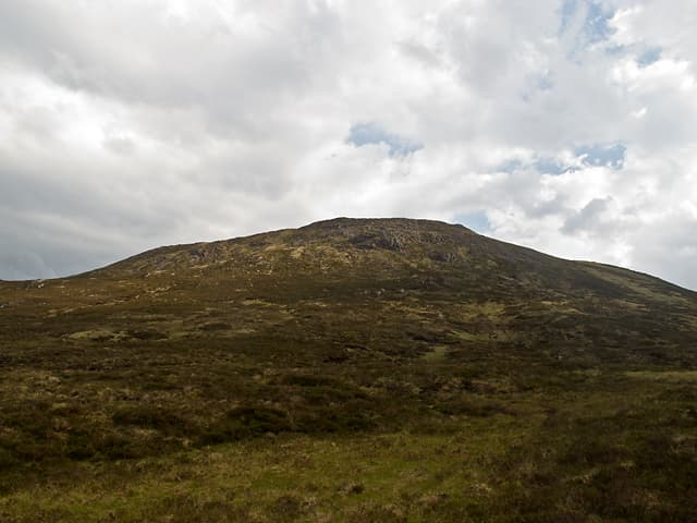
Glas Mheall Mor — the big grey lump — is an 829m Marilyn in NN-square Perthshire, sitting above Loch Errochty between Trinafour and the southern end of the Drumochter pass. The summit gives a wide vista south over Strath Tummel to Schiehallion and west to the Ben Alder hills.
Gaelic: “grey-green, rounded hill, big” · Pronunciation: glass mheall more
Quick facts
- Height
- 829.3m/ 2721ft
- Prominence
- 147 m
- Grid ref
- NN 56339 67294
- Nearest city
- Fort William· 46km
- Dogs
- Dogs on lead required near livestockDog-friendly guide ↗
Sub-Marilyn: 147m of drop — misses the 150m Marilyn cut by 3m. We keep it on the list as a near-miss.
Height and prominence cross-checked against the Database of British and Irish Hills (CC BY).
No GPX track yet
Walked this route? Share your track to help other walkers.
Standard route
heather moorland 65% · grass slopes 25% · rocky summit 10%
A common start is the Trinafour layby on the old A9, taking the estate track up Glen Errochty to Calvine before climbing the broad south-east shoulder. Alternative routes come in from Dalnaspidal on the north, slightly shorter but harder underfoot through peat groughs.
Terrain
Estate track for the lower kilometres, then heather and bilberry on the upper shoulder. The summit dome is bouldery quartzite with patches of bog cotton in the hollows.
In winter
A genuine Corbett-height plateau exposed to the worst of Drumochter weather. Cornices form on the steep north-east face; the broad rounded summit demands accurate bearings in cloud. Full winter kit from late November.
This hill is in the Northern Cairngorms SAIS forecast area. Check SAIS forecasts in winter (December–April).
Best time of year
Getting there
- Glasgow2h 23m
- Edinburgh4h 41m
OS maps: OS Landranger 42, OS Explorer 385E
Mobile signal: Poor. Remote Breadalbane; limited coverage.
Current conditions
Daylight Today
- Sunrise
- 05:13
- Sunset
- 21:35
- Civil dawn
- 04:22
- Civil dusk
- 22:26
NOAA Solar Calculator · 30 July 2026
Around Glas Mheall Mor on the SCOT network
Getting there, basing yourself, and what to do off the hill.
Getting there: Rannoch station
Rannoch Moor — remote West Highland Line stop; Schiehallion approach via bus
17km from the hill
tripscot.co.uk
On TripSCOTBase yourself in Aberfeldy
Loch Tay base — Ben Lawers, Tarmachan ridge, Birks of Aberfeldy
34km from the hill
tripscot.co.uk
On TasteSCOTAfter the hill: Dalwhinnie
Dalwhinnie — Scotland's highest distillery on the Drumochter pass
19km from the hill
tastescot.co.uk
Glas Mheall Mor — common questions
- How difficult is Glas Mheall Mor?
- Glas Mheall Mor carries a 3/5 (moderately challenging) grade on the OutdoorSCOT scale. Terrain: Estate track for the lower kilometres, then heather and bilberry on the upper shoulder.
- How prominent is Glas Mheall Mor?
- Glas Mheall Mor has 147m of topographic prominence — the height of its summit above the highest col connecting it to higher ground. That leaves it 3m short of the 150m drop a Marilyn needs — DoBIH classes it a sub-Marilyn, a near-miss rather than a full Marilyn.
- When should I climb Glas Mheall Mor?
- The standard good-weather months for Glas Mheall Mor are April, May, June, September. Outside those months, expect winter conditions on the high ground — full mountain kit, navigation skills, and a check of the SAIS avalanche forecast for the relevant region.
- Can I bring my dog up Glas Mheall Mor?
- On a lead only — the route crosses ground with livestock or nesting-bird interest.
- What's mobile reception like on Glas Mheall Mor?
- Poor. Remote Breadalbane; limited coverage.
- Is Glas Mheall Mor safe in winter?
- A genuine Corbett-height plateau exposed to the worst of Drumochter weather. Cornices form on the steep north-east face; the broad rounded summit demands accurate bearings in cloud. Full winter kit from late November.
Get the OutdoorSCOT weekly
One email a week — new route, hill and bothy guides, seasonal conditions and the odd hard-won lesson. No spam, unsubscribe in one click.