Marilyn · Cairngorms
The Bochel
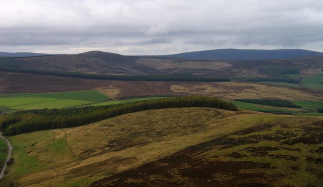
A modest 491m grouse moor in the upper Braes of Glenlivet, set among the meandering Conglass and Crombie burns. The Bochel is a true country walker's hill — quiet, lightly visited and steeped in the heather-and-whisky atmosphere of this hidden corner of Speyside.
Quick facts
- Height
- 491.2m/ 1612ft
- Prominence
- 155 m
- Grid ref
- NJ 23251 23248
- Nearest city
- Inverness· 61km
- Dogs
- Dogs on lead required near livestockDog-friendly guide ↗
Height and prominence cross-checked against the Database of British and Irish Hills (CC BY).
No GPX track yet
Walked this route? Share your track to help other walkers.
Standard route
heather moorland 65% · grass slopes 25% · rocky summit 10%
From the road near Chapeltown of Glenlivet, take the estate track south then strike west onto the rounded summit dome. About 5km return with under 250m of ascent — a relaxed two hours, perfect for an afternoon outing.
Terrain
Estate tracks for most of the way then a short heather climb to the summit. The ground is dry by Speyside standards — well-managed grouse moor with firm peat.
In winter
Snow blankets the moor regularly from December but the ground is gentle enough to walk in light cover. Stalking ends in late October so winter is the prime season here.
This hill is in the Northern Cairngorms SAIS forecast area. Check SAIS forecasts in winter (December–April).
Best time of year
Getting there
- Glasgow4h 29m
- Edinburgh3h 29m
OS maps: OS Landranger 36, OS Explorer 062W, OS Explorer 420W
Mobile signal: Moderate. EE works well at Chapeltown; the summit gives a fair signal but coverage is patchy on the western descent.
Current conditions
Daylight Today
- Sunrise
- 05:06
- Sunset
- 21:33
- Civil dawn
- 04:13
- Civil dusk
- 22:26
NOAA Solar Calculator · 30 July 2026
Around The Bochel on the SCOT network
Getting there, basing yourself, and what to do off the hill.
Getting there: Aviemore station
Cairngorm plateau; Lairig Ghru; Speyside Way; Glenmore
35km from the hill
tripscot.co.uk
On TripSCOTBase yourself in Dufftown
Speyside whisky town in the eastern Cairngorms
19km from the hill
tripscot.co.uk
On TasteSCOTAfter the hill: The Glenlivet
Ballindalloch — the first legal distillery under the 1823 Excise Act
5km from the hill
tastescot.co.uk
The Bochel — common questions
- How hard is The Bochel?
- We grade The Bochel at 1/5, which puts it in easy territory. Terrain: Estate tracks for most of the way then a short heather climb to the summit.
- How prominent is The Bochel?
- The Bochel has 155m of topographic prominence — the height of its summit above the highest col connecting it to higher ground. Marilyns are defined by that measure: at least 150m of drop on all sides.
- When should I climb The Bochel?
- The standard good-weather months for The Bochel are March, April, May, June, July, August, September, October. Outside those months, expect winter conditions on the high ground — full mountain kit, navigation skills, and a check of the SAIS avalanche forecast for the relevant region.
- Can I bring my dog up The Bochel?
- On a lead only — the route crosses ground with livestock or nesting-bird interest.
- What's mobile reception like on The Bochel?
- Moderate. EE works well at Chapeltown; the summit gives a fair signal but coverage is patchy on the western descent.
- Is The Bochel safe in winter?
- Snow blankets the moor regularly from December but the ground is gentle enough to walk in light cover. Stalking ends in late October so winter is the prime season here.
Get the OutdoorSCOT weekly
One email a week — new route, hill and bothy guides, seasonal conditions and the odd hard-won lesson. No spam, unsubscribe in one click.