Marilyn · North-West Highlands
Struie
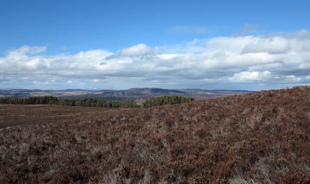
Struie — the nose or projecting point — rises to 373m at NH 658 849 above the famous viewpoint on the B9176 Struie road. The summit looks south across the Dornoch Firth to the Easter Ross peninsula and is one of the most popular short hill walks north of Inverness.
Quick facts
- Height
- 373m/ 1224ft
- Prominence
- 157 m
- Grid ref
- NH 65843 84985
- Nearest city
- Inverness· 40km
- Dogs
- Dogs on lead required near livestockDog-friendly guide ↗
Height and prominence cross-checked against the Database of British and Irish Hills (CC BY).
No GPX track yet
Walked this route? Share your track to help other walkers.
Standard route
heather moorland 60% · grass slopes 30% · rocky summit 10%
From the Struie viewpoint car park on the B9176, a clear path leads up the south-east shoulder for 1.5km to the summit. An hour up, half an hour down. Suitable for families with hill-walking experience.
Terrain
Old Red Sandstone with a thin covering of cropped heather. The path is well-trodden and dry underfoot; the summit is a flat grassy area with a viewpoint indicator and small cairn.
In winter
Snow lies briefly after east-coast falls but clears quickly. The hill is popular as a winter walk when conditions are too tough higher up; the path can be icy in places but the gradient is gentle.
This hill is in the Torridon SAIS forecast area. Check SAIS forecasts in winter (December–April).
Best time of year
Getting there
- Glasgow5h 6m
- Edinburgh6h 36m
OS maps: OS Landranger 21, OS Explorer 438W
Mobile signal: Good summit signal; EE holds throughout. Fine views to Cromarty Firth and Easter Ross.
Current conditions
Daylight Today
- Sunrise
- 05:07
- Sunset
- 21:40
- Civil dawn
- 04:12
- Civil dusk
- 22:35
NOAA Solar Calculator · 30 July 2026
Around Struie on the SCOT network
Getting there, basing yourself, and what to do off the hill.
Getting there: Ardgay station
Kyle of Sutherland; Croick; Far North Line
8km from the hill
tripscot.co.uk
On TripSCOTBase yourself in Inverness
Highland capital — gateway to Cairngorms, Affric, Far North
40km from the hill
tripscot.co.uk
On TasteSCOTAfter the hill: Balblair
Edderton — Easter Ross distillery with vintage-led range
5km from the hill
tastescot.co.uk
Struie — common questions
- How difficult is Struie?
- Struie carries a 1/5 (easy) grade on the OutdoorSCOT scale. Underfoot: Old Red Sandstone with a thin covering of cropped heather.
- What is Struie's prominence?
- 157m of prominence. That's the vertical drop from the summit to the col that links Struie to the next higher ground. That drop is what qualifies it as a Marilyn — a hill with at least 150m of descent on every side.
- When is the best time to climb Struie?
- March, April, May, June, July, August, September, October give the most reliable conditions on Struie. Beyond that window the high ground turns wintry: carry full mountain kit, be confident navigating, and check the SAIS avalanche forecast for the area.
- Is Struie dog-friendly?
- Yes, but dogs must be kept on a lead — there is livestock or ground-nesting bird interest on the route.
- Is there mobile signal on Struie?
- Good summit signal; EE holds throughout. Fine views to Cromarty Firth and Easter Ross.
- Is Struie safe in winter?
- Snow lies briefly after east-coast falls but clears quickly. The hill is popular as a winter walk when conditions are too tough higher up; the path can be icy in places but the gradient is gentle.
Get the OutdoorSCOT weekly
One email a week — new route, hill and bothy guides, seasonal conditions and the odd hard-won lesson. No spam, unsubscribe in one click.