Marilyn · Ochils
Stronend
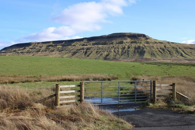
Stronend stands at the western end of the Fintry Hills in the NS 629 grid square, rising abruptly above the Endrick valley. The 511m top is the climax of a long basalt escarpment with dramatic crags on its northern face that drop towards the Carron reservoir.
Quick facts
- Height
- 511m/ 1677ft
- Prominence
- 286 m
- Grid ref
- NS 62927 89472
- Nearest city
- Stirling· 17km
- Dogs
- Dogs on lead required near livestockDog-friendly guide ↗
Height and prominence cross-checked against the Database of British and Irish Hills (CC BY).
No GPX track yet
Walked this route? Share your track to help other walkers.
Standard route
volcanic basalt 45% · grass slopes 40% · heather moorland 15%
A direct approach climbs from the B818 in the Carron valley up through forestry and onto the open ridge, following the line of the escarpment to the summit. Around 8-10km and 2.5-3.5 hours with stiffer gradients than the Stronend's gentle southern aspect suggests.
Terrain
Rough grass and heather on the broad summit with a sharp crag-edge that demands respect on the north side. Drainage is good except in a peaty hollow east of the trig.
In winter
Snow lies in shaded north-facing gullies long after the surrounding ground clears. The cliff-edge in misty winter conditions calls for very careful navigation away from the brink.
Best time of year
Getting there
- Glasgow1h 34m
- Edinburgh3h 38m
OS maps: OS Landranger 57, OS Explorer 348
Mobile signal: Good. Central belt; EE and Vodafone reliable. Good connectivity throughout.
Current conditions
Daylight Today
- Sunrise
- 05:16
- Sunset
- 21:30
- Civil dawn
- 04:27
- Civil dusk
- 22:20
NOAA Solar Calculator · 30 July 2026
Around Stronend on the SCOT network
Getting there, basing yourself, and what to do off the hill.
Getting there: Stirling station
Ochils, Dumyat, Stirling Castle, Wallace Monument
17km from the hill
tripscot.co.uk
On TripSCOTBase yourself in Callander
Trossachs gateway — Ben Ledi, Stuc a Chroin, Rob Roy Way
19km from the hill
tripscot.co.uk
On TasteSCOTAfter the hill: Deanston
Doune — converted cotton mill; floral, honeyed Perthshire distillery
14km from the hill
tastescot.co.uk
Stronend — common questions
- How hard is Stronend?
- We grade Stronend at 2/5, which puts it in moderate territory. Underfoot: Rough grass and heather on the broad summit with a sharp crag-edge that demands respect on the north side.
- What is Stronend's prominence?
- 286m of prominence. That's the vertical drop from the summit to the col that links Stronend to the next higher ground. That drop is what qualifies it as a Marilyn — a hill with at least 150m of descent on every side.
- When is the best time to climb Stronend?
- March, April, May, June, July, August, September, October give the most reliable conditions on Stronend. Beyond that window the high ground turns wintry: carry full mountain kit, be confident navigating, and check the SAIS avalanche forecast for the area.
- Is Stronend dog-friendly?
- Yes, but dogs must be kept on a lead — there is livestock or ground-nesting bird interest on the route.
- Is there mobile signal on Stronend?
- Good. Central belt; EE and Vodafone reliable. Good connectivity throughout.
- Is Stronend safe in winter?
- Snow lies in shaded north-facing gullies long after the surrounding ground clears. The cliff-edge in misty winter conditions calls for very careful navigation away from the brink.
Get the OutdoorSCOT weekly
One email a week — new route, hill and bothy guides, seasonal conditions and the odd hard-won lesson. No spam, unsubscribe in one click.