Marilyn · Ochils
Carleatheran
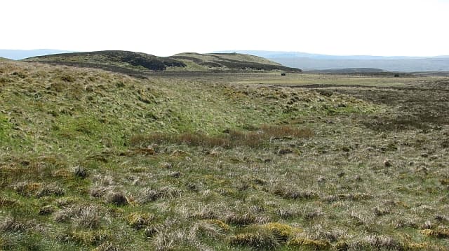
Carleatheran is the highest point of the Gargunnock Hills, an extension of the Campsies in the NS 687 grid square south of the Forth valley. The 485m broad summit looks north across Stirling and the carse towards the southern Highlands.
Quick facts
- Height
- 485m/ 1591ft
- Prominence
- 168 m
- Grid ref
- NS 68792 91869
- Nearest city
- Stirling· 11km
- Dogs
- Dogs on lead required near livestockDog-friendly guide ↗
Height and prominence cross-checked against the Database of British and Irish Hills (CC BY).
No GPX track yet
Walked this route? Share your track to help other walkers.
Standard route
volcanic basalt 45% · heather moorland 35% · grass slopes 20%
A long approach from the Gargunnock road follows farm tracks before climbing the heather slopes onto the escarpment edge. Once on the plateau, an easy walk leads to the small summit cairn. Around 12-14km and 3-4 hours.
Terrain
A wild plateau of peat hags and tussock grass that is hard work in summer and easier when frozen. The basalt scarp on the northern edge gives sudden drops to the carse.
In winter
Best tackled in firm winter conditions when the peat hags freeze solid. The exposed plateau collects spindrift and the cliff edge requires a wide berth in misty weather.
Best time of year
Getting there
- Glasgow1h 43m
- Edinburgh2h 25m
OS maps: OS Landranger 57, OS Explorer 348
Mobile signal: Good. Stirlingshire/Central belt; EE reliable.
Current conditions
Daylight Today
- Sunrise
- 06:45
- Sunset
- 19:39
- Civil dawn
- 06:08
- Civil dusk
- 20:17
NOAA Solar Calculator · 14 September 2026
Around Carleatheran on the SCOT network
Getting there, basing yourself, and what to do off the hill.
Getting there: Stirling station
Ochils, Dumyat, Stirling Castle, Wallace Monument
11km from the hill
tripscot.co.uk
On TripSCOTBase yourself in Callander
Trossachs gateway — Ben Ledi, Stuc a Chroin, Rob Roy Way
17km from the hill
tripscot.co.uk
On TasteSCOTAfter the hill: Deanston
Doune — converted cotton mill; floral, honeyed Perthshire distillery
9km from the hill
tastescot.co.uk
Carleatheran — common questions
- What difficulty is Carleatheran?
- On the OutdoorSCOT scale, Carleatheran comes in at 1/5 — easy. Underfoot: A wild plateau of peat hags and tussock grass that is hard work in summer and easier when frozen.
- What is Carleatheran's prominence?
- 168m of prominence. That's the vertical drop from the summit to the col that links Carleatheran to the next higher ground. That drop is what qualifies it as a Marilyn — a hill with at least 150m of descent on every side.
- When is the best time to climb Carleatheran?
- March, April, May, June, July, August, September, October give the most reliable conditions on Carleatheran. Beyond that window the high ground turns wintry: carry full mountain kit, be confident navigating, and check the SAIS avalanche forecast for the area.
- Is Carleatheran dog-friendly?
- Yes, but dogs must be kept on a lead — there is livestock or ground-nesting bird interest on the route.
- Is there mobile signal on Carleatheran?
- Good. Stirlingshire/Central belt; EE reliable.
- Is Carleatheran safe in winter?
- Best tackled in firm winter conditions when the peat hags freeze solid. The exposed plateau collects spindrift and the cliff edge requires a wide berth in misty weather.
Get the OutdoorSCOT weekly
One email a week — new route, hill and bothy guides, seasonal conditions and the odd hard-won lesson. No spam, unsubscribe in one click.