Marilyn · Argyll & Bute
Sgorr nam Faoileann
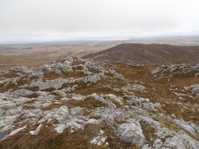
Sgorr nam Faoileann — the Peak of the Gulls — is a 429m Marilyn on south-eastern Islay, forming part of the same wild moorland chain as Beinn Bheigier and Glas Bheinn. The summit gives sweeping views over the Sound of Jura.
Quick facts
- Height
- 429m/ 1407ft
- Prominence
- 171 m
- Grid ref
- NR 43302 60650
- Dogs
- Dogs on lead required near livestockDog-friendly guide ↗
Height and prominence cross-checked against the Database of British and Irish Hills (CC BY).
No GPX track yet
Walked this route? Share your track to help other walkers.
Standard route
heather and bog 60% · rocky slopes 25% · grass slopes 15%
Reached from the same Ardtalla starting point, often as a three-summit traverse with its higher neighbours. As a stand-alone outing expect a 3-hour round trip across rough terrain.
Terrain
Open Islay moorland of heather and peat. The upper slopes have some short rocky steps but nothing approaching a scramble.
In winter
Wind is the perennial concern. Snow is rare and never deep. A clear winter day on this ridge can give superb visibility for hours.
Best time of year
Getting there
- Glasgow5h 46m
- Edinburgh8h 32m
Ferry access
Kennacraig → Port Askaig or Port Ellen
- Crossing time135 min
- Summer sailings2–3 sailings daily (Apr–Oct)
- Winter sailings1–2 sailings daily (Nov–Mar)
- Book ahead14 days
- Last ferry backCheck CalMac timetable
OS maps: OS Landranger 60, OS Explorer 352
Mobile signal: Minimal. signal falls away en route; Islay's eastern moorland has no coverage.
Current conditions
Daylight Today
- Sunrise
- 05:25
- Sunset
- 21:36
- Civil dawn
- 04:37
- Civil dusk
- 22:25
NOAA Solar Calculator · 30 July 2026
Around Sgorr nam Faoileann on the SCOT network
Getting there, basing yourself, and what to do off the hill.
Sgorr nam Faoileann — common questions
- What difficulty is Sgorr nam Faoileann?
- On the OutdoorSCOT scale, Sgorr nam Faoileann comes in at 1/5 — easy. Underfoot: Open Islay moorland of heather and peat.
- What is Sgorr nam Faoileann's prominence?
- 171m of prominence. That's the vertical drop from the summit to the col that links Sgorr nam Faoileann to the next higher ground. That drop is what qualifies it as a Marilyn — a hill with at least 150m of descent on every side.
- When is the best time to climb Sgorr nam Faoileann?
- March, April, May, June, July, August, September, October give the most reliable conditions on Sgorr nam Faoileann. Beyond that window the high ground turns wintry: carry full mountain kit, be confident navigating, and check the SAIS avalanche forecast for the area.
- Is Sgorr nam Faoileann dog-friendly?
- Yes, but dogs must be kept on a lead — there is livestock or ground-nesting bird interest on the route.
- Is there mobile signal on Sgorr nam Faoileann?
- Minimal. signal falls away en route; Islay's eastern moorland has no coverage.
- How do I get the ferry to Sgorr nam Faoileann?
- Kennacraig → Port Askaig or Port Ellen. 2–3 sailings daily (Apr–Oct) in summer; 1–2 sailings daily (Nov–Mar) in winter. Book at least 14 days ahead.
- Is Sgorr nam Faoileann safe in winter?
- Wind is the perennial concern. Snow is rare and never deep. A clear winter day on this ridge can give superb visibility for hours.
Get the OutdoorSCOT weekly
One email a week — new route, hill and bothy guides, seasonal conditions and the odd hard-won lesson. No spam, unsubscribe in one click.