Marilyn · Argyll & Bute
Beinn Bheigier
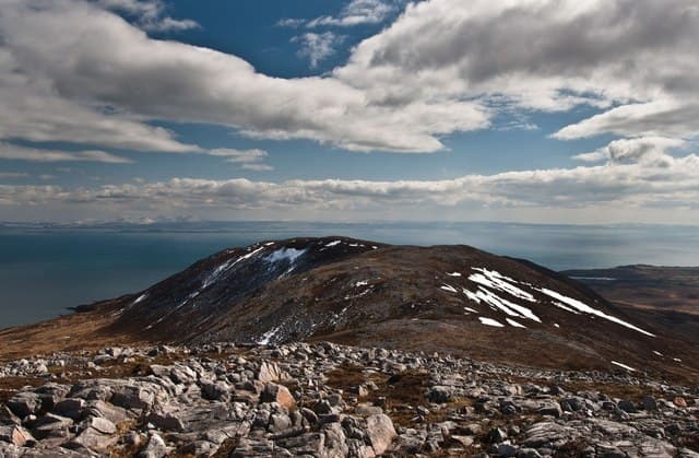
Beinn Bheigier is the high point of Islay at 491m, rising above the wild south-eastern moorland of the island. On clear days the view reaches Ireland — the Antrim coast and even the Mournes visible across the sea.
Quick facts
- Height
- 491m/ 1611ft
- Prominence
- 491 m
- Grid ref
- NR 42998 56458
- Dogs
- Dogs on lead required near livestockDog-friendly guide ↗
Height and prominence cross-checked against the Database of British and Irish Hills (CC BY).
No GPX track yet
Walked this route? Share your track to help other walkers.
Standard route
heather moorland 60% · rocky slopes 25% · grass slopes 15%
The standard line begins from Ardtalla on the east coast and follows the deer fence north-west to the open hill. There is no path; the going is rough but never technical. Round trip 4-5 hours.
Terrain
Wet heather, peat and tussocks throughout. Some firmer rocky ground close to the summit cairn. Boots and gaiters strongly recommended.
In winter
Islay winters are wild but rarely cold enough for prolonged snow. Storms, not ice, are the main winter obstacle. Pick a calm day and the walk is straightforward.
Best time of year
Getting there
- Glasgow5h 47m
- Edinburgh8h 32m
Ferry access
Kennacraig → Port Askaig or Port Ellen
- Crossing time135 min
- Summer sailings2–3 sailings daily (Apr–Oct)
- Winter sailings1–2 sailings daily (Nov–Mar)
- Book ahead14 days
- Last ferry backCheck CalMac timetable
OS maps: OS Landranger 60, OS Explorer 352
Mobile signal: Poor. No EE signal; Islay's remote moorland has limited coverage inland.
Current conditions
Daylight Today
- Sunrise
- 05:26
- Sunset
- 21:36
- Civil dawn
- 04:37
- Civil dusk
- 22:25
NOAA Solar Calculator · 30 July 2026
Around Beinn Bheigier on the SCOT network
Getting there, basing yourself, and what to do off the hill.
Beinn Bheigier — common questions
- How difficult is Beinn Bheigier?
- Beinn Bheigier carries a 1/5 (easy) grade on the OutdoorSCOT scale. Terrain: Wet heather, peat and tussocks throughout.
- How prominent is Beinn Bheigier?
- Beinn Bheigier's prominence is its full height — 491m — because it is the highest point of its landmass, with no higher ground connected to it. Marilyns are defined by that measure: at least 150m of drop on all sides.
- When should I climb Beinn Bheigier?
- The standard good-weather months for Beinn Bheigier are March, April, May, June, July, August, September, October. Outside those months, expect winter conditions on the high ground — full mountain kit, navigation skills, and a check of the SAIS avalanche forecast for the relevant region.
- Can I bring my dog up Beinn Bheigier?
- On a lead only — the route crosses ground with livestock or nesting-bird interest.
- What's mobile reception like on Beinn Bheigier?
- Poor. No EE signal; Islay's remote moorland has limited coverage inland.
- How do I get the ferry to Beinn Bheigier?
- Kennacraig → Port Askaig or Port Ellen. 2–3 sailings daily (Apr–Oct) in summer; 1–2 sailings daily (Nov–Mar) in winter. Book at least 14 days ahead.
- Is Beinn Bheigier safe in winter?
- Islay winters are wild but rarely cold enough for prolonged snow. Storms, not ice, are the main winter obstacle. Pick a calm day and the walk is straightforward.
Get the OutdoorSCOT weekly
One email a week — new route, hill and bothy guides, seasonal conditions and the odd hard-won lesson. No spam, unsubscribe in one click.