Marilyn · Skye & The Small Isles
Sgorr an Fharaidh
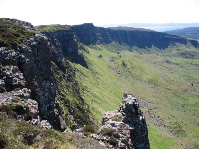
Sgorr an Fharaidh is a 340m clifftop summit at the north end of the Isle of Eigg, ending in sheer columnar basalt that plunges straight to the sea. The view from the edge to Rum and the Cuillin is unmatched in the Small Isles.
Quick facts
- Height
- 340m/ 1115ft
- Prominence
- 264 m
- Grid ref
- NM 48541 89297
- Dogs
- Dogs on lead required near livestockDog-friendly guide ↗
Height and prominence cross-checked against the Database of British and Irish Hills (CC BY).
No GPX track yet
Walked this route? Share your track to help other walkers.
Standard route
heather moorland 50% · rocky slopes 35% · grass slopes 15%
From Cleadale on the north of Eigg take farm tracks then open moor to gain the clifftop, following it north-east to the summit. Around 5 km return from Cleadale.
Terrain
Cropped grass and heather over basalt platforms. The cliffs are entirely unfenced and the edges undercut in places — stay well back, especially in wind.
In winter
Snow rare but the constant Atlantic wind and exposed cliff edge make this a dangerous winter outing in poor visibility.
Best time of year
Getting there
- Glasgow6h 36m
- Edinburgh8h 2m
Ferry access
Mallaig → Eigg
- Crossing time105 min
- Summer sailings4–5 sailings per week (Apr–Oct); also served from Arisaig by Arisaig Marine
- Winter sailings2 sailings per week (Nov–Mar)
- Book ahead14 days
- Last ferry backDay trips possible in summer — check timetable, ferry also serves other Small Isles
OS maps: OS Landranger 39, OS Explorer 397
Mobile signal: Poor. Inner Hebrides; all networks fail. Ferry and offline maps required.
Current conditions
Daylight Today
- Sunrise
- 05:19
- Sunset
- 21:43
- Civil dawn
- 04:28
- Civil dusk
- 22:34
NOAA Solar Calculator · 30 July 2026
Around Sgorr an Fharaidh on the SCOT network
Getting there, basing yourself, and what to do off the hill.
Sgorr an Fharaidh — common questions
- Is Sgorr an Fharaidh a hard climb?
- Sgorr an Fharaidh is rated 1/5 (easy) on the OutdoorSCOT scale. Ground conditions: Cropped grass and heather over basalt platforms.
- How much drop does Sgorr an Fharaidh have?
- The drop is 264m: measured from the summit of Sgorr an Fharaidh down to the saddle joining it to higher terrain. Passing the 150m-drop threshold on all sides is exactly what makes it a Marilyn.
- What's the best month to climb Sgorr an Fharaidh?
- Aim for March, April, May, June, July, August, September, October on Sgorr an Fharaidh. In the remaining months treat it as a winter hill — full kit, solid navigation, and a look at the relevant SAIS avalanche forecast before you go.
- Can dogs go up Sgorr an Fharaidh?
- Dogs are fine on a lead. The route passes livestock or ground-nesting bird habitat, so keep them close throughout.
- Will I get phone signal on Sgorr an Fharaidh?
- Poor. Inner Hebrides; all networks fail. Ferry and offline maps required.
- How do I get the ferry to Sgorr an Fharaidh?
- Mallaig → Eigg. 4–5 sailings per week (Apr–Oct); also served from Arisaig by Arisaig Marine in summer; 2 sailings per week (Nov–Mar) in winter. Book at least 14 days ahead.
- Is Sgorr an Fharaidh safe in winter?
- Snow rare but the constant Atlantic wind and exposed cliff edge make this a dangerous winter outing in poor visibility.
Get the OutdoorSCOT weekly
One email a week — new route, hill and bothy guides, seasonal conditions and the odd hard-won lesson. No spam, unsubscribe in one click.