Marilyn · Skye & The Small Isles
An Sgurr
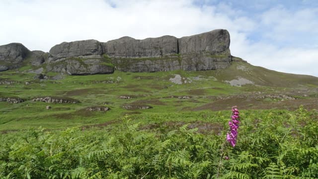
An Sgurr of Eigg is the most distinctive island peak in Britain — a 393m fortress of pitchstone lava rising vertically from the moorland. The summit walk is one of the great Hebridean day-trips, accessed by passenger ferry from Mallaig or Arisaig.
Quick facts
- Height
- 394m/ 1293ft
- Grid ref
- NM 46321 84700
- Dogs
- Dogs on lead required near livestockDog-friendly guide ↗
No GPX track yet
Walked this route? Share your track to help other walkers.
Standard route
pitchstone lava 50% · rough grassland 30% · rocky scramble 20%
From the pier follow the marked path past Galmisdale, swinging round the south side of the Sgurr to climb the only weakness — a steep ramp on the south-east. About 7 km return.
Terrain
Path is good but very wet in places across boggy moor. The final ramp on the pitchstone is steep and slabby — secure when dry, slick when wet.
In winter
Pitchstone glazes lethally in ice. Ferry schedules also thin in winter so most parties wait for spring or summer to attempt the Sgurr.
Best time of year
Getting there
- Glasgow6h 37m
- Edinburgh8h 4m
Ferry access
Mallaig → Eigg
- Crossing time105 min
- Summer sailings4–5 sailings per week (Apr–Oct); also served from Arisaig by Arisaig Marine
- Winter sailings2 sailings per week (Nov–Mar)
- Book ahead14 days
- Last ferry backDay trips possible in summer — check timetable, ferry also serves other Small Isles
OS maps: OS Landranger 39, OS Explorer 397
Mobile signal: Poor. Isle of Eigg; limited coverage near Cleadale.
Current conditions
Daylight Today
- Sunrise
- 04:33
- Sunset
- 22:22
- Civil dawn
- 03:26
- Civil dusk
- 23:29
NOAA Solar Calculator · 27 June 2026
Around An Sgurr on the SCOT network
Getting there, basing yourself, and what to do off the hill.
Getting there: Morar station
Silver Sands, Knoydart approach, Loch Morar
22km from the hill
tripscot.co.uk
On TripSCOTBase yourself in Mallaig
Ferry port for Skye and the Small Isles; CWT finish supply
25km from the hill
tripscot.co.uk
On TasteSCOTAfter the hill: Tobermory
Mull — colourful harbour-front distillery making both unpeated and peated (Ledaig) whisky
30km from the hill
tastescot.co.uk
An Sgurr — common questions
- How hard is An Sgurr?
- An Sgurr is rated 1/5 (easy) on the OutdoorSCOT scale. Terrain: Path is good but very wet in places across boggy moor.
- When is the best time to climb An Sgurr?
- The standard good-weather months for An Sgurr are March, April, May, June, July, August, September, October. Outside those months, expect winter conditions on the high ground — full mountain kit, navigation skills, and a check of the SAIS avalanche forecast for the relevant region.
- Can I bring my dog up An Sgurr?
- Yes, but dogs must be kept on a lead — there is livestock or ground-nesting bird interest on the route.
- Is there mobile signal on An Sgurr?
- Poor. Isle of Eigg; limited coverage near Cleadale.
- How do I get the ferry to An Sgurr?
- Mallaig → Eigg. 4–5 sailings per week (Apr–Oct); also served from Arisaig by Arisaig Marine in summer; 2 sailings per week (Nov–Mar) in winter. Book at least 14 days ahead.
- Is An Sgurr safe in winter?
- Pitchstone glazes lethally in ice. Ferry schedules also thin in winter so most parties wait for spring or summer to attempt the Sgurr.
Get the OutdoorSCOT weekly
One email a week — new route, hill and bothy guides, seasonal conditions and the odd hard-won lesson. No spam, unsubscribe in one click.