Marilyn · Central Highlands
Meall Mor
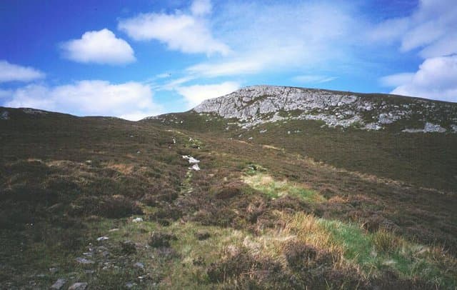
A nondescript-looking 492m hill east of Inverness, north of the A9 corridor near Tomatin. Despite the unassuming profile, the broad summit gives a striking view across the Findhorn valley and out to the Moray coast. The hill is hardly visited despite being only minutes from a major road.
Gaelic: “rounded hill, big” · Pronunciation: myowl more
Quick facts
- Height
- 492m/ 1614ft
- Grid ref
- NH 73736 35566
- Nearest city
- Inverness· 12km
- Dogs
- Dogs on lead required near livestockDog-friendly guide ↗
No GPX track yet
Walked this route? Share your track to help other walkers.
Standard route
heather moorland 65% · grass slopes 25% · mossy ground 10%
A short approach from Findhorn Bridge follows a forestry track before breaking out onto open moor. Pick a line directly for the trig pillar; 5km return in 90 minutes is typical.
Terrain
Brashings underfoot near recently felled blocks of conifer, then dry heather and grass mosaic on the open upper hill. No streams to cross on the standard line.
In winter
Cold air pooling in the Findhorn valley sometimes gives this hill a long frost while the summit sits above the inversion. A bright early-morning ascent in February gives memorable views over the cloud-filled strath below.
This hill is in the Creag Meagaidh SAIS forecast area. Check SAIS forecasts in winter (December–April).
Best time of year
Getting there
- Glasgow4h 59m
- Edinburgh4h 25m
OS maps: OS Landranger 27, OS Explorer 416N
Mobile signal: Moderate. EE intermittent; better toward Inverness.
Current conditions
Daylight Today
- Sunrise
- 04:21
- Sunset
- 22:18
- Civil dawn
- 03:10
- Civil dusk
- 23:29
NOAA Solar Calculator · 27 June 2026
Around Meall Mor on the SCOT network
Getting there, basing yourself, and what to do off the hill.
Getting there: Inverness station
Highland capital — Cairngorms east side, Affric, Far North via bus/car
12km from the hill
tripscot.co.uk
On TripSCOTBase yourself in Inverness
Highland capital — gateway to Cairngorms, Affric, Far North
12km from the hill
tripscot.co.uk
On TasteSCOTAfter the hill: Tomatin
Tomatin — large Highland distillery just off the A9, south of Inverness
8km from the hill
tastescot.co.uk
Meall Mor — common questions
- How hard is Meall Mor?
- Meall Mor is rated 1/5 (easy) on the OutdoorSCOT scale. Terrain: Brashings underfoot near recently felled blocks of conifer, then dry heather and grass mosaic on the open upper hill.
- When is the best time to climb Meall Mor?
- The standard good-weather months for Meall Mor are March, April, May, June, July, August, September, October. Outside those months, expect winter conditions on the high ground — full mountain kit, navigation skills, and a check of the SAIS avalanche forecast for the relevant region.
- Can I bring my dog up Meall Mor?
- Yes, but dogs must be kept on a lead — there is livestock or ground-nesting bird interest on the route.
- Is there mobile signal on Meall Mor?
- Moderate. EE intermittent; better toward Inverness.
- Is Meall Mor safe in winter?
- Cold air pooling in the Findhorn valley sometimes gives this hill a long frost while the summit sits above the inversion. A bright early-morning ascent in February gives memorable views over the cloud-filled strath below.
Get the OutdoorSCOT weekly
One email a week — new route, hill and bothy guides, seasonal conditions and the odd hard-won lesson. No spam, unsubscribe in one click.