Marilyn · North-West Highlands
Meall Glac Tigh-fail
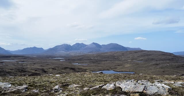
Meall Glac Tigh-fail — the rounded hill of the hollow of the fold-house — stands 521m at NH 161 827 on the moorland north of Loch Maree and Letterewe. The Gaelic refers to a sheltered hollow once used as a stock fold; the hill sits on the northern flank of the great Letterewe-Fisherfield wilderness.
Quick facts
- Height
- 521m/ 1709ft
- Prominence
- 178 m
- Grid ref
- NH 16132 82772
- Nearest city
- Inverness· 63km
- Dogs
- Dogs on lead required near livestockDog-friendly guide ↗
Height and prominence cross-checked against the Database of British and Irish Hills (CC BY).
No GPX track yet
Walked this route? Share your track to help other walkers.
Standard route
blanket bog 50% · heather moorland 35% · grassy summit 15%
Most parties approach from the Poolewe road, taking the Kernsary track east before breaking south onto the hill. It is a 5-6 hour day on rough ground with no fixed route after the path runs out, so good map reading is essential.
Terrain
Knock-and-lochan country of Lewisian gneiss with tightly braided peat channels between the outcrops. The summit is a low rocky pavement rather than a defined point; the going is harder than the contour spacing suggests.
In winter
Marine-cool rather than alpine. Snow falls but rarely lies long below 500m here; what does lie collects in the peat hollows and disguises the worst of the bog. Daylight is short — start before first light in midwinter.
This hill is in the Torridon SAIS forecast area. Check SAIS forecasts in winter (December–April).
Best time of year
Getting there
- Glasgow5h 28m
- Edinburgh7h 52m
OS maps: OS Landranger 20, OS Explorer 436N
Mobile signal: Poor. All networks fail; the Assynt area has very limited mobile infrastructure.
Current conditions
Daylight Today
- Sunrise
- 05:10
- Sunset
- 21:44
- Civil dawn
- 04:16
- Civil dusk
- 22:38
NOAA Solar Calculator · 30 July 2026
Around Meall Glac Tigh-fail on the SCOT network
Getting there, basing yourself, and what to do off the hill.
Meall Glac Tigh-fail — common questions
- Is Meall Glac Tigh-fail a hard climb?
- Meall Glac Tigh-fail is rated 2/5 (moderate) on the OutdoorSCOT scale. Terrain: Knock-and-lochan country of Lewisian gneiss with tightly braided peat channels between the outcrops.
- How prominent is Meall Glac Tigh-fail?
- Meall Glac Tigh-fail has 178m of topographic prominence — the height of its summit above the highest col connecting it to higher ground. Marilyns are defined by that measure: at least 150m of drop on all sides.
- When should I climb Meall Glac Tigh-fail?
- The standard good-weather months for Meall Glac Tigh-fail are March, April, May, June, July, August, September, October. Outside those months, expect winter conditions on the high ground — full mountain kit, navigation skills, and a check of the SAIS avalanche forecast for the relevant region.
- Can I bring my dog up Meall Glac Tigh-fail?
- On a lead only — the route crosses ground with livestock or nesting-bird interest.
- What's mobile reception like on Meall Glac Tigh-fail?
- Poor. All networks fail; the Assynt area has very limited mobile infrastructure.
- Is Meall Glac Tigh-fail safe in winter?
- Marine-cool rather than alpine. Snow falls but rarely lies long below 500m here; what does lie collects in the peat hollows and disguises the worst of the bog. Daylight is short — start before first light in midwinter.
Get the OutdoorSCOT weekly
One email a week — new route, hill and bothy guides, seasonal conditions and the odd hard-won lesson. No spam, unsubscribe in one click.