Marilyn · North-West Highlands
Meall Coire an Lochain
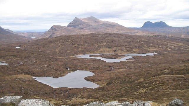
Meall Coire an Lochain — rounded hill of the corrie of the small loch — rises to 517m at NC 211 065 in the empty country south of Inchnadamph. The lochan in its east-facing corrie is unusually circular and is held in by a moraine ridge from the last glaciation.
Gaelic: “rounded hill, corrie, the, small loch” · Pronunciation: myowl kor-a an loch-een
Quick facts
- Height
- 517m/ 1696ft
- Prominence
- 182 m
- Grid ref
- NC 21185 06510
- Nearest city
- Inverness· 76km
- Dogs
- Dogs on lead required near livestockDog-friendly guide ↗
Height and prominence cross-checked against the Database of British and Irish Hills (CC BY).
No GPX track yet
Walked this route? Share your track to help other walkers.
Standard route
heather moorland 55% · lochside bog 25% · rocky summit 20%
Most accessible from the A837 near Loch Borralan, walking south-east across open moor for 3km before climbing onto the east shoulder. There is no path; expect 4 hours on the round trip.
Terrain
Moine schist with intrusive granite, giving a varied summit area of pavement and boulder field. The corrie lochan is set among Salisbury Crags-style cliffs of dark rock — a striking contrast against the pale moor.
In winter
The lochan freezes by mid-December most years and provides a useful navigation anchor in cloud. The east aspect of the corrie holds deep snow into May; the summit ridge above blows clear in any breeze.
This hill is in the Torridon SAIS forecast area. Check SAIS forecasts in winter (December–April).
Best time of year
Getting there
- Glasgow6h 55m
- Edinburgh7h 9m
OS maps: OS Landranger 15, OS Explorer 439E
Mobile signal: Poor. Networks fail completely; download offline maps before departing.
Current conditions
Daylight Today
- Sunrise
- 05:09
- Sunset
- 21:45
- Civil dawn
- 04:14
- Civil dusk
- 22:39
NOAA Solar Calculator · 30 July 2026
Around Meall Coire an Lochain on the SCOT network
Getting there, basing yourself, and what to do off the hill.
Meall Coire an Lochain — common questions
- Is Meall Coire an Lochain a hard climb?
- Meall Coire an Lochain is rated 2/5 (moderate) on the OutdoorSCOT scale. Ground conditions: Moine schist with intrusive granite, giving a varied summit area of pavement and boulder field.
- How much drop does Meall Coire an Lochain have?
- The drop is 182m: measured from the summit of Meall Coire an Lochain down to the saddle joining it to higher terrain. Passing the 150m-drop threshold on all sides is exactly what makes it a Marilyn.
- What's the best month to climb Meall Coire an Lochain?
- Aim for March, April, May, June, July, August, September, October on Meall Coire an Lochain. In the remaining months treat it as a winter hill — full kit, solid navigation, and a look at the relevant SAIS avalanche forecast before you go.
- Can dogs go up Meall Coire an Lochain?
- Dogs are fine on a lead. The route passes livestock or ground-nesting bird habitat, so keep them close throughout.
- Will I get phone signal on Meall Coire an Lochain?
- Poor. Networks fail completely; download offline maps before departing.
- Is Meall Coire an Lochain safe in winter?
- The lochan freezes by mid-December most years and provides a useful navigation anchor in cloud. The east aspect of the corrie holds deep snow into May; the summit ridge above blows clear in any breeze.
Get the OutdoorSCOT weekly
One email a week — new route, hill and bothy guides, seasonal conditions and the odd hard-won lesson. No spam, unsubscribe in one click.