Marilyn · North-West Highlands
Meall an Fhuarain
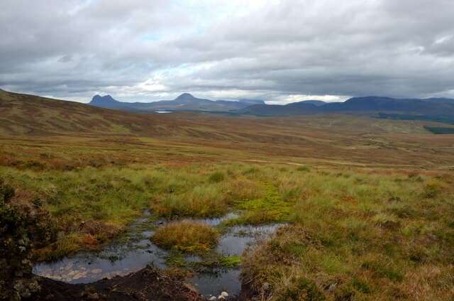
Meall an Fhuarain — rounded hill of the spring — rises to 578m at NC 280 023 on the moor north of Oykel Bridge. The name marks a perennial spring on its eastern flank, still flowing strongly even in dry summers and noted on the OS map as a watering point for the deer forest.
Quick facts
- Height
- 578m/ 1896ft
- Prominence
- 341 m
- Grid ref
- NC 28052 02364
- Nearest city
- Inverness· 69km
- Dogs
- Dogs on lead required near livestockDog-friendly guide ↗
Height and prominence cross-checked against the Database of British and Irish Hills (CC BY).
No GPX track yet
Walked this route? Share your track to help other walkers.
Standard route
heather moorland 60% · grass slopes 25% · rocky summit 15%
Walk in from the A837 at Rosehall, following the Cassley track north for around 5km before turning west onto open hill. The spring at NC 285 020 makes a natural lunch stop. A 5-6 hour round trip.
Terrain
Mostly Moine schist with bands of limestone outcropping near the spring — unusual in this part of Sutherland and reflected in greener turf around the water. The summit ground is dry heather and short grass.
In winter
Springs that flow year-round provide useful navigation marks in snow. The hill faces east and dries quickly; on the cold-clear days of late winter it makes a fine viewpoint across to Ben More Assynt without the commitment.
This hill is in the Torridon SAIS forecast area. Check SAIS forecasts in winter (December–April).
Best time of year
Getting there
- Glasgow6h 44m
- Edinburgh7h 53m
OS maps: OS Landranger 15, OS Explorer 439E
Mobile signal: Poor. Remote Sutherland or Wester Ross; limited coverage.
Current conditions
Daylight Today
- Sunrise
- 05:08
- Sunset
- 21:44
- Civil dawn
- 04:14
- Civil dusk
- 22:39
NOAA Solar Calculator · 30 July 2026
Around Meall an Fhuarain on the SCOT network
Getting there, basing yourself, and what to do off the hill.
Meall an Fhuarain — common questions
- What difficulty is Meall an Fhuarain?
- On the OutdoorSCOT scale, Meall an Fhuarain comes in at 2/5 — moderate. Ground conditions: Mostly Moine schist with bands of limestone outcropping near the spring — unusual in this part of Sutherland and reflected in greener turf around the water.
- How much drop does Meall an Fhuarain have?
- The drop is 341m: measured from the summit of Meall an Fhuarain down to the saddle joining it to higher terrain. Passing the 150m-drop threshold on all sides is exactly what makes it a Marilyn.
- What's the best month to climb Meall an Fhuarain?
- Aim for March, April, May, June, July, August, September, October on Meall an Fhuarain. In the remaining months treat it as a winter hill — full kit, solid navigation, and a look at the relevant SAIS avalanche forecast before you go.
- Can dogs go up Meall an Fhuarain?
- Dogs are fine on a lead. The route passes livestock or ground-nesting bird habitat, so keep them close throughout.
- Will I get phone signal on Meall an Fhuarain?
- Poor. Remote Sutherland or Wester Ross; limited coverage.
- Is Meall an Fhuarain safe in winter?
- Springs that flow year-round provide useful navigation marks in snow. The hill faces east and dries quickly; on the cold-clear days of late winter it makes a fine viewpoint across to Ben More Assynt without the commitment.
Get the OutdoorSCOT weekly
One email a week — new route, hill and bothy guides, seasonal conditions and the odd hard-won lesson. No spam, unsubscribe in one click.