Sub-Marilyn · North-West Highlands
An Laogh
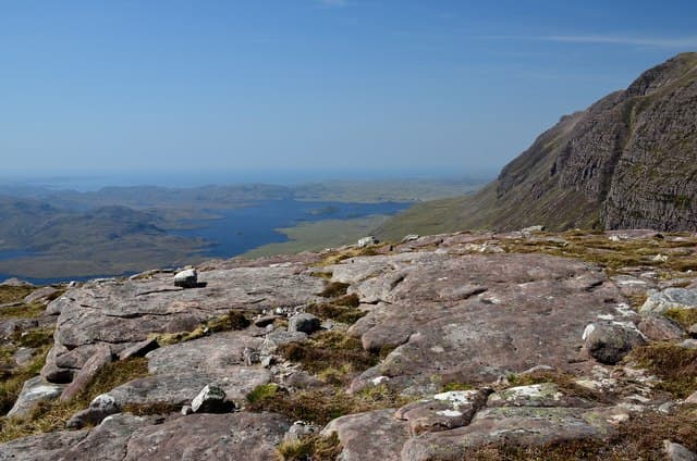
An Laogh — the Calf — is a satellite of Cul Mor in the Inverpolly tangle south of Lochinver. The NC 16 10 grid places it among the lochans of Loch Sionascaig, with views over the Cromalt Hills and back to the unmistakable outline of Suilven.
Quick facts
- Height
- 546.6m/ 1793ft
- Prominence
- 147 m
- Grid ref
- NC 16176 10213
- Nearest city
- Inverness· 82km
- Dogs
- Dogs on lead required near livestockDog-friendly guide ↗
Sub-Marilyn: 147m of drop — misses the 150m Marilyn cut by 3m. We keep it on the list as a near-miss.
Height and prominence cross-checked against the Database of British and Irish Hills (CC BY).
No GPX track yet
Walked this route? Share your track to help other walkers.
Standard route
blanket bog 55% · heather moorland 30% · grassy summit 15%
Park at Linneraineach (NC 14 06) on the Drumrunie–Achiltibuie road and walk in north-west across pathless moor. A long heathery pull up the south-east shoulder gains the summit, marked by a small cairn on shattered sandstone. Around 10 km return with 480m of climb.
Terrain
Pathless from the start, with deep heather and frequent peat hags on the approach. Higher up the going firms to short turf interspersed with Torridonian sandstone outcrops.
In winter
A consolidated snow cover transforms the heathery slog into a fast walk, but the south-east shoulder is exposed to prevailing south-westerlies. Cornices can form on the north edge above Loch Sionascaig.
This hill is in the Torridon SAIS forecast area. Check SAIS forecasts in winter (December–April).
Best time of year
Getting there
- Glasgow6h 4m
- Edinburgh7h 21m
OS maps: OS Landranger 15, OS Explorer 439E
Mobile signal: Poor. Signal drops completely on the approach track; all networks fail here.
Current conditions
Daylight Today
- Sunrise
- 05:09
- Sunset
- 21:45
- Civil dawn
- 04:14
- Civil dusk
- 22:40
NOAA Solar Calculator · 30 July 2026
Around An Laogh on the SCOT network
Getting there, basing yourself, and what to do off the hill.
An Laogh — common questions
- How hard is An Laogh?
- We grade An Laogh at 2/5, which puts it in moderate territory. Underfoot: Pathless from the start, with deep heather and frequent peat hags on the approach.
- What is An Laogh's prominence?
- 147m of prominence. That's the vertical drop from the summit to the col that links An Laogh to the next higher ground. That leaves it 3m short of the 150m drop a Marilyn needs — DoBIH classes it a sub-Marilyn, a near-miss rather than a full Marilyn.
- When is the best time to climb An Laogh?
- March, April, May, June, July, August, September, October give the most reliable conditions on An Laogh. Beyond that window the high ground turns wintry: carry full mountain kit, be confident navigating, and check the SAIS avalanche forecast for the area.
- Is An Laogh dog-friendly?
- Yes, but dogs must be kept on a lead — there is livestock or ground-nesting bird interest on the route.
- Is there mobile signal on An Laogh?
- Poor. Signal drops completely on the approach track; all networks fail here.
- Is An Laogh safe in winter?
- A consolidated snow cover transforms the heathery slog into a fast walk, but the south-east shoulder is exposed to prevailing south-westerlies. Cornices can form on the north edge above Loch Sionascaig.
Get the OutdoorSCOT weekly
One email a week — new route, hill and bothy guides, seasonal conditions and the odd hard-won lesson. No spam, unsubscribe in one click.