Marilyn · North-West Highlands
Beinn Reidh
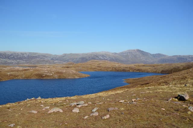
Beinn Reidh — the Smooth Hill — fronts Loch Assynt to the north and looks across to Quinag's sandstone wall. The NC 21 21 grid puts the summit on the divide between Glen Leireag and Loch nan Caorach, an area of low gneiss bosses and shining lochans.
Gaelic: “mountain, smooth” · Pronunciation: bine ray
Quick facts
- Height
- 567m/ 1860ft
- Prominence
- 172 m
- Grid ref
- NC 21128 21225
- Nearest city
- Inverness· 88km
- Dogs
- Dogs on lead required near livestockDog-friendly guide ↗
Height and prominence cross-checked against the Database of British and Irish Hills (CC BY).
No GPX track yet
Walked this route? Share your track to help other walkers.
Standard route
heather and bog 65% · grass slopes 25% · rocky summit 10%
Park in the unfenced layby beside the A894 at NC 21 25 and head south through tussocky grass to gain the broad north ridge. The summit is a featureless grassy dome with a small cairn, and on a clear day Quinag's entire ridge is laid out opposite. Around 7 km return with 420m of climb.
Terrain
Lewisian gneiss outcrops break up gently rolling slopes of bog cotton and short grass. Despite the name "Smooth", the lower flank holds many small wet hollows that need weaving around.
In winter
A short window of good winter walking exists when the bogs freeze and a thin snow cover smooths the gneiss. In poor visibility the featureless plateau is a serious navigational test.
This hill is in the Torridon SAIS forecast area. Check SAIS forecasts in winter (December–April).
Best time of year
Getting there
- Glasgow6h 15m
- Edinburgh7h 26m
OS maps: OS Landranger 15, OS Explorer 442E
Mobile signal: Poor. Far north Sutherland; EE and Vodafone both absent. PLB essential.
Current conditions
Daylight Today
- Sunrise
- 05:08
- Sunset
- 21:45
- Civil dawn
- 04:13
- Civil dusk
- 22:41
NOAA Solar Calculator · 30 July 2026
Around Beinn Reidh on the SCOT network
Getting there, basing yourself, and what to do off the hill.
Beinn Reidh — common questions
- Is Beinn Reidh a hard climb?
- Beinn Reidh is rated 2/5 (moderate) on the OutdoorSCOT scale. Underfoot: Lewisian gneiss outcrops break up gently rolling slopes of bog cotton and short grass.
- What is Beinn Reidh's prominence?
- 172m of prominence. That's the vertical drop from the summit to the col that links Beinn Reidh to the next higher ground. That drop is what qualifies it as a Marilyn — a hill with at least 150m of descent on every side.
- When is the best time to climb Beinn Reidh?
- March, April, May, June, July, August, September, October give the most reliable conditions on Beinn Reidh. Beyond that window the high ground turns wintry: carry full mountain kit, be confident navigating, and check the SAIS avalanche forecast for the area.
- Is Beinn Reidh dog-friendly?
- Yes, but dogs must be kept on a lead — there is livestock or ground-nesting bird interest on the route.
- Is there mobile signal on Beinn Reidh?
- Poor. Far north Sutherland; EE and Vodafone both absent. PLB essential.
- Is Beinn Reidh safe in winter?
- A short window of good winter walking exists when the bogs freeze and a thin snow cover smooths the gneiss. In poor visibility the featureless plateau is a serious navigational test.
Get the OutdoorSCOT weekly
One email a week — new route, hill and bothy guides, seasonal conditions and the odd hard-won lesson. No spam, unsubscribe in one click.