Marilyn · Argyll & Bute
Maol Ban
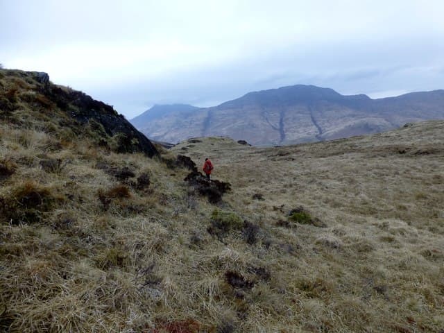
Maol Ban — the White Bare Hill — sits at 338m above Lochbuie on the south coast of Mull, named for its pale grasses that catch the morning light from the sea. Although low, its position above the coast gives an arresting outlook across the Firth of Lorn to the Garvellachs and Jura.
Gaelic: “fair” · Pronunciation: maol bahn
Quick facts
- Height
- 338.3m/ 1110ft
- Prominence
- 152 m
- Grid ref
- NM 68384 23873
- Nearest city
- Oban· 19km
- Dogs
- Dogs on lead required near livestockDog-friendly guide ↗
Height and prominence cross-checked against the Database of British and Irish Hills (CC BY).
No GPX track yet
Walked this route? Share your track to help other walkers.
Standard route
heather and bog 65% · grass slopes 25% · rocky summit 10%
Drive the long single-track road to Lochbuie and park at the village green near the post box. Head north up the hillside behind the houses on a faint sheep track to the summit. Around 2.5 hours return.
Terrain
Pale Molinia grass and short heather over a rocky base, with bracken stands lower down. The going is firm and dry compared with much of inland Mull.
In winter
A coastal hill that very rarely sees snow. Winter walks here are mostly about timing the showers and dealing with low slanting sun on the descent.
Best time of year
Getting there
- Glasgow4h 5m
- Edinburgh7h 42m
Ferry access
Oban → Craignure
- Crossing time45 min
- Summer sailingsUp to 8 sailings daily (Apr–Oct)
- Winter sailings4–5 sailings daily (Nov–Mar)
- Book ahead7 days
- Last ferry backCheck CalMac timetable — sailings run until ~21:00 in peak summer
Foot passengers can usually turn up without booking. Book vehicle spaces in advance. The Lochaline → Fishnish crossing (15 min) is shorter but serves east Mull only.
Book on CalMac ↗OS maps: OS Landranger 49, OS Explorer 375E
Mobile signal: Poor. EE missing; first coverage near Salen or the A849.
Current conditions
Daylight Today
- Sunrise
- 05:21
- Sunset
- 21:38
- Civil dawn
- 04:31
- Civil dusk
- 22:28
NOAA Solar Calculator · 30 July 2026
Around Maol Ban on the SCOT network
Getting there, basing yourself, and what to do off the hill.
Getting there: Oban station
Argyll ferry hub; Mull, Lismore, Coll, Tiree, Barra connections
18km from the hill
tripscot.co.uk
On TripSCOTBase yourself in Oban
Argyll ferry hub — Mull, Lismore, Coll, Tiree, Barra
18km from the hill
tripscot.co.uk
On TasteSCOTAfter the hill: Oban
Oban town centre — tiny two-still distillery bridging Highland and West Coast styles
18km from the hill
tastescot.co.uk
Maol Ban — common questions
- How hard is Maol Ban?
- We grade Maol Ban at 1/5, which puts it in easy territory. Underfoot: Pale Molinia grass and short heather over a rocky base, with bracken stands lower down.
- What is Maol Ban's prominence?
- 152m of prominence. That's the vertical drop from the summit to the col that links Maol Ban to the next higher ground. That drop is what qualifies it as a Marilyn — a hill with at least 150m of descent on every side.
- When is the best time to climb Maol Ban?
- March, April, May, June, July, August, September, October give the most reliable conditions on Maol Ban. Beyond that window the high ground turns wintry: carry full mountain kit, be confident navigating, and check the SAIS avalanche forecast for the area.
- Is Maol Ban dog-friendly?
- Yes, but dogs must be kept on a lead — there is livestock or ground-nesting bird interest on the route.
- Is there mobile signal on Maol Ban?
- Poor. EE missing; first coverage near Salen or the A849.
- How do I get the ferry to Maol Ban?
- Oban → Craignure. Up to 8 sailings daily (Apr–Oct) in summer; 4–5 sailings daily (Nov–Mar) in winter. Book at least 7 days ahead. Foot passengers can usually turn up without booking. Book vehicle spaces in advance. The Lochaline → Fishnish crossing (15 min) is shorter but serves east Mull only.
- Is Maol Ban safe in winter?
- A coastal hill that very rarely sees snow. Winter walks here are mostly about timing the showers and dealing with low slanting sun on the descent.
Get the OutdoorSCOT weekly
One email a week — new route, hill and bothy guides, seasonal conditions and the odd hard-won lesson. No spam, unsubscribe in one click.