Marilyn · Argyll
Beinn Mhor
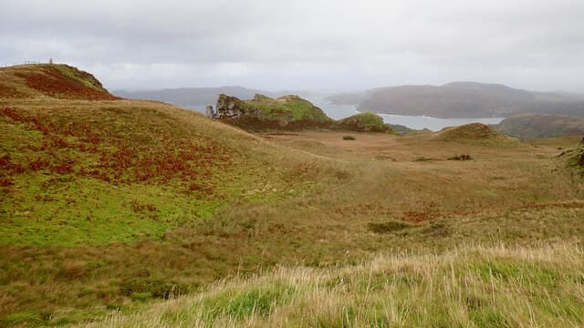
Despite its grand name — Big Hill — this Beinn Mhor reaches only 194m above Loch Melfort, yet still earns Marilyn status. From the top a tangle of sea lochs, islets and skerries on the Craignish coastline lies spread below.
Gaelic: “mountain, big” · Pronunciation: bine vore
Quick facts
- Height
- 194m/ 636ft
- Grid ref
- NM 79842 21579
- Nearest city
- Oban· 10km
- Dogs
- Dogs on lead required near livestockDog-friendly guide ↗
No GPX track yet
Walked this route? Share your track to help other walkers.
Standard route
heather moorland 55% · grass slopes 30% · rocky summit 15%
A track from near Arduaine climbs through mixed woodland and rhododendron to gain open ground, with a final scramble onto the rocky summit knoll. Roughly two hours return.
Terrain
Sheep-grazed pasture and bracken near the start, with patches of greasy rock on the final knoll. Damp moss and lichen call for sticky soles.
In winter
Coastal position keeps snow at bay; the rocky top can be slick after rain or frost. Pleasant on a calm winter afternoon.
Best time of year
Getting there
- Glasgow4h 37m
- Edinburgh6h 13m
OS maps: OS Landranger 49, OS Explorer 359
Mobile signal: Poor. Craignish/Loch Melfort area; intermittent coverage.
Current conditions
Daylight Today
- Sunrise
- 04:35
- Sunset
- 22:15
- Civil dawn
- 03:31
- Civil dusk
- 23:19
NOAA Solar Calculator · 27 June 2026
Around Beinn Mhor on the SCOT network
Getting there, basing yourself, and what to do off the hill.
Getting there: Oban station
Argyll ferry hub; Mull, Lismore, Coll, Tiree, Barra connections
10km from the hill
tripscot.co.uk
On TripSCOTBase yourself in Oban
Argyll ferry hub — Mull, Lismore, Coll, Tiree, Barra
10km from the hill
tripscot.co.uk
On TasteSCOTAfter the hill: Oban
Oban town centre — tiny two-still distillery bridging Highland and West Coast styles
10km from the hill
tastescot.co.uk
Beinn Mhor — common questions
- How hard is Beinn Mhor?
- Beinn Mhor is rated 1/5 (easy) on the OutdoorSCOT scale. Terrain: Sheep-grazed pasture and bracken near the start, with patches of greasy rock on the final knoll.
- When is the best time to climb Beinn Mhor?
- The standard good-weather months for Beinn Mhor are March, April, May, June, July, August, September, October. Outside those months, expect winter conditions on the high ground — full mountain kit, navigation skills, and a check of the SAIS avalanche forecast for the relevant region.
- Can I bring my dog up Beinn Mhor?
- Yes, but dogs must be kept on a lead — there is livestock or ground-nesting bird interest on the route.
- Is there mobile signal on Beinn Mhor?
- Poor. Craignish/Loch Melfort area; intermittent coverage.
- Is Beinn Mhor safe in winter?
- Coastal position keeps snow at bay; the rocky top can be slick after rain or frost. Pleasant on a calm winter afternoon.
Get the OutdoorSCOT weekly
One email a week — new route, hill and bothy guides, seasonal conditions and the odd hard-won lesson. No spam, unsubscribe in one click.