Marilyn · Cairngorms
Kerloch
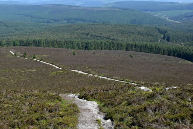
Kerloch is a substantial 534m forested whaleback rising directly south of Banchory on Royal Deeside. The conifer-clad lower slopes give way to a heather-and-bog summit area, with the trig perched on the highest of several humps and a view extending to the Mounth hills.
Quick facts
- Height
- 534m/ 1752ft
- Prominence
- 181 m
- Grid ref
- NO 69653 87879
- Nearest city
- Aberdeen· 31km
- Dogs
- Dogs on lead required near livestockDog-friendly guide ↗
Height and prominence cross-checked against the Database of British and Irish Hills (CC BY).
No GPX track yet
Walked this route? Share your track to help other walkers.
Standard route
heather moorland 65% · grass slopes 25% · rocky summit 10%
The standard line follows forest roads from the Glen Dye car park, climbing steadily through Sitka plantation before a final pathless 1km of heather to the trig point. About 11km return, allow 3 to 4 hours.
Terrain
Forest road as far as the treeline, then heather and patches of squelchy peat moss to the top. Watch for forest harvesting closures and follow Forestry and Land Scotland diversion signs.
In winter
Forest roads usually stay walkable in snow and offer a sheltered low-level option when the higher Mounth hills are out of condition. The exposed summit dome can ice up after thaw-and-refreeze.
This hill is in the Northern Cairngorms SAIS forecast area. Check SAIS forecasts in winter (December–April).
Best time of year
Getting there
- Glasgow5h 22m
- Edinburgh3h 12m
OS maps: OS Landranger 45, OS Explorer 396
Mobile signal: Solid summit coverage; EE works well. Fine Angus and Deeside views.
Current conditions
Daylight Today
- Sunrise
- 05:05
- Sunset
- 21:28
- Civil dawn
- 04:13
- Civil dusk
- 22:20
NOAA Solar Calculator · 30 July 2026
Around Kerloch on the SCOT network
Getting there, basing yourself, and what to do off the hill.
Kerloch — common questions
- How difficult is Kerloch?
- Kerloch carries a 2/5 (moderate) grade on the OutdoorSCOT scale. Underfoot: Forest road as far as the treeline, then heather and patches of squelchy peat moss to the top.
- What is Kerloch's prominence?
- 181m of prominence. That's the vertical drop from the summit to the col that links Kerloch to the next higher ground. That drop is what qualifies it as a Marilyn — a hill with at least 150m of descent on every side.
- When is the best time to climb Kerloch?
- March, April, May, June, July, August, September, October give the most reliable conditions on Kerloch. Beyond that window the high ground turns wintry: carry full mountain kit, be confident navigating, and check the SAIS avalanche forecast for the area.
- Is Kerloch dog-friendly?
- Yes, but dogs must be kept on a lead — there is livestock or ground-nesting bird interest on the route.
- Is there mobile signal on Kerloch?
- Solid summit coverage; EE works well. Fine Angus and Deeside views.
- Is Kerloch safe in winter?
- Forest roads usually stay walkable in snow and offer a sheltered low-level option when the higher Mounth hills are out of condition. The exposed summit dome can ice up after thaw-and-refreeze.
Get the OutdoorSCOT weekly
One email a week — new route, hill and bothy guides, seasonal conditions and the odd hard-won lesson. No spam, unsubscribe in one click.