Marilyn · Cairngorms
Hill of Garvock
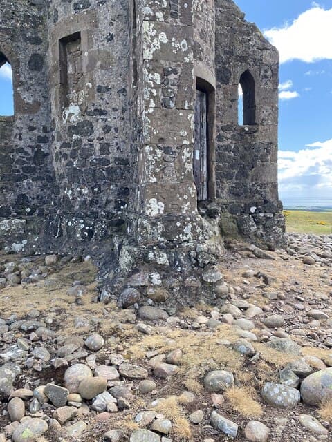
A modest 277m ridge above Laurencekirk in the Howe of the Mearns, crowned by Johnstons Tower — a Victorian folly raised by a local laird in 1813. The hill is steeped in murky local history including a tale of a sheriff being boiled by angry tenants in 1420.
Quick facts
- Height
- 277m/ 909ft
- Prominence
- 219 m
- Grid ref
- NO 72665 69178
- Nearest city
- Aberdeen· 43km
- Dogs
- Dogs on lead required near livestockDog-friendly guide ↗
Height and prominence cross-checked against the Database of British and Irish Hills (CC BY).
No GPX track yet
Walked this route? Share your track to help other walkers.
Standard route
heather moorland 65% · grass slopes 25% · summit area 10%
From Lauriston Castle road, follow a marked path through farmland and small woods to the tower, then a short turf-and-bracken pull to the trig pillar. A 4km circuit takes about 1.5 hours.
Terrain
Field tracks and stiles below, then close-cropped grass to the trig. The path can be slick after heavy rain where it crosses heavy clay soils.
In winter
Snow seldom lies given the low elevation and coastal proximity. The tower makes a fine landmark in any weather, and the view of distant white Mounth tops is striking on crisp days.
This hill is in the Northern Cairngorms SAIS forecast area. Check SAIS forecasts in winter (December–April).
Best time of year
Getting there
- Glasgow5h 16m
- Edinburgh3h 56m
OS maps: OS Landranger 45, OS Explorer 382N
Mobile signal: Solid summit coverage; EE behaves well. Mearns viewpoint overlooking Laurencekirk.
Current conditions
Daylight Today
- Sunrise
- 05:05
- Sunset
- 21:27
- Civil dawn
- 04:14
- Civil dusk
- 22:19
NOAA Solar Calculator · 30 July 2026
Around Hill of Garvock on the SCOT network
Getting there, basing yourself, and what to do off the hill.
Hill of Garvock — common questions
- How hard is Hill of Garvock?
- We grade Hill of Garvock at 1/5, which puts it in easy territory. Terrain: Field tracks and stiles below, then close-cropped grass to the trig.
- How prominent is Hill of Garvock?
- Hill of Garvock has 219m of topographic prominence — the height of its summit above the highest col connecting it to higher ground. Marilyns are defined by that measure: at least 150m of drop on all sides.
- When should I climb Hill of Garvock?
- The standard good-weather months for Hill of Garvock are March, April, May, June, July, August, September, October. Outside those months, expect winter conditions on the high ground — full mountain kit, navigation skills, and a check of the SAIS avalanche forecast for the relevant region.
- Can I bring my dog up Hill of Garvock?
- On a lead only — the route crosses ground with livestock or nesting-bird interest.
- What's mobile reception like on Hill of Garvock?
- Solid summit coverage; EE behaves well. Mearns viewpoint overlooking Laurencekirk.
- Is Hill of Garvock safe in winter?
- Snow seldom lies given the low elevation and coastal proximity. The tower makes a fine landmark in any weather, and the view of distant white Mounth tops is striking on crisp days.
Get the OutdoorSCOT weekly
One email a week — new route, hill and bothy guides, seasonal conditions and the odd hard-won lesson. No spam, unsubscribe in one click.