Marilyn · Outer Hebrides
Heileasbhal Mor
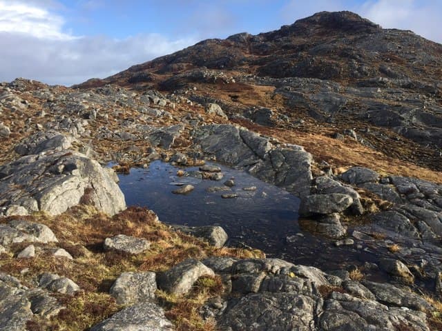
Heileasbhal Mor is a quiet 384m hill in the lumpy hill country of south Harris, just west of An Coileach. It looks across to Roineabhal and out over the Sound of Harris to North Uist and the Monach Isles.
Gaelic: “big” · Pronunciation: heileasbhal more
Quick facts
- Height
- 384m/ 1260ft
- Prominence
- 177 m
- Grid ref
- NG 07351 92745
- Dogs
- Dogs on lead required near livestockDog-friendly guide ↗
Height and prominence cross-checked against the Database of British and Irish Hills (CC BY).
No GPX track yet
Walked this route? Share your track to help other walkers.
Standard route
Lewisian gneiss 45% · blanket bog 35% · rocky summit 20%
A short walk-in from the A859 climbs the rough east side onto the broad summit dome. About three hours return through pathless heather and bog with stretches of bare gneiss.
Terrain
Knolly gneiss terrain with peaty hollows and small lochans. Drier ground on the rocky shoulders provides easier going.
In winter
Mild winters but ground often saturated and the bare rock slick when frozen. Strong gales sweep over the col from the Atlantic.
Best time of year
Getting there
- Glasgow9h 36m
- Edinburgh11h 50m
Ferry access
Uig (Skye) → Tarbert (Harris)
- Crossing time105 min
- Summer sailings2 sailings daily (Apr–Oct)
- Winter sailings1 sailing daily (Nov–Mar)
- Book ahead14 days
- Last ferry backCheck CalMac timetable — last sailing to Uig varies seasonally
Drive to Uig on Skye (Skye Bridge from Kyle of Lochalsh), then ferry to Harris. Alternative: Ullapool → Stornoway (Lewis, 2h45) and drive south.
Book on CalMac ↗OS maps: OS Landranger 14, OS Landranger 18, OS Explorer 455
Mobile signal: Poor. No EE signal; Harris interior has virtually no coverage.
Current conditions
Daylight Today
- Sunrise
- 06:55
- Sunset
- 19:52
- Civil dawn
- 06:15
- Civil dusk
- 20:32
NOAA Solar Calculator · 14 September 2026
Around Heileasbhal Mor on the SCOT network
Getting there, basing yourself, and what to do off the hill.
Heileasbhal Mor — common questions
- Is Heileasbhal Mor a hard climb?
- Heileasbhal Mor is rated 1/5 (easy) on the OutdoorSCOT scale. Terrain: Knolly gneiss terrain with peaty hollows and small lochans.
- How prominent is Heileasbhal Mor?
- Heileasbhal Mor has 177m of topographic prominence — the height of its summit above the highest col connecting it to higher ground. Marilyns are defined by that measure: at least 150m of drop on all sides.
- When should I climb Heileasbhal Mor?
- The standard good-weather months for Heileasbhal Mor are March, April, May, June, July, August, September, October. Outside those months, expect winter conditions on the high ground — full mountain kit, navigation skills, and a check of the SAIS avalanche forecast for the relevant region.
- Can I bring my dog up Heileasbhal Mor?
- On a lead only — the route crosses ground with livestock or nesting-bird interest.
- What's mobile reception like on Heileasbhal Mor?
- Poor. No EE signal; Harris interior has virtually no coverage.
- How do I get the ferry to Heileasbhal Mor?
- Uig (Skye) → Tarbert (Harris). 2 sailings daily (Apr–Oct) in summer; 1 sailing daily (Nov–Mar) in winter. Book at least 14 days ahead. Drive to Uig on Skye (Skye Bridge from Kyle of Lochalsh), then ferry to Harris. Alternative: Ullapool → Stornoway (Lewis, 2h45) and drive south.
- Is Heileasbhal Mor safe in winter?
- Mild winters but ground often saturated and the bare rock slick when frozen. Strong gales sweep over the col from the Atlantic.
Get the OutdoorSCOT weekly
One email a week — new route, hill and bothy guides, seasonal conditions and the odd hard-won lesson. No spam, unsubscribe in one click.