Marilyn · Outer Hebrides
Greabhal
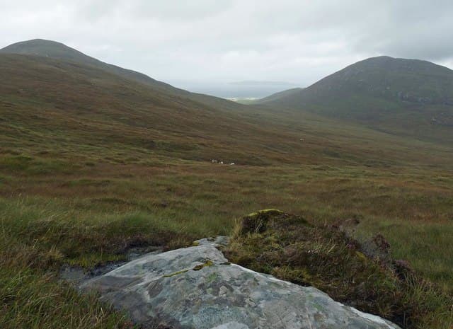
Sitting between Loch Langabhat and the wild South Harris coastline, Greabhal is a quietly satisfying 280m top crowned with rocky knolls. The view stretches across the Sound of Harris to North Uist and the scattered isles of the channel.
Quick facts
- Height
- 280m/ 919ft
- Prominence
- 194 m
- Grid ref
- NG 00386 89161
- Dogs
- Dogs on lead required near livestockDog-friendly guide ↗
Height and prominence cross-checked against the Database of British and Irish Hills (CC BY).
No GPX track yet
Walked this route? Share your track to help other walkers.
Standard route
blanket bog 50% · Lewisian gneiss 35% · rocky summit 15%
Most parties begin from the A859 near Lingreabhagh and pick a line northeast across moorland to gain the broad ridge. The summit cairn lies at the high point of a tangle of rocky bumps; allow about three hours return.
Terrain
Knolly gneiss bedrock interspersed with shallow lochans and peat hollows. There are no paths and route choice is constant. Expect to weave around outcrops rather than follow any direct line.
In winter
A wet rather than snowy winter venue, with Atlantic gales driving rain straight across the open moor. Short daylight and saturated ground are the main hazards rather than ice or snow cover.
Best time of year
Getting there
- Glasgow9h 47m
- Edinburgh11h 3m
Ferry access
Uig (Skye) → Tarbert (Harris)
- Crossing time105 min
- Summer sailings2 sailings daily (Apr–Oct)
- Winter sailings1 sailing daily (Nov–Mar)
- Book ahead14 days
- Last ferry backCheck CalMac timetable — last sailing to Uig varies seasonally
Drive to Uig on Skye (Skye Bridge from Kyle of Lochalsh), then ferry to Harris. Alternative: Ullapool → Stornoway (Lewis, 2h45) and drive south.
Book on CalMac ↗OS maps: OS Landranger 18, OS Explorer 455
Mobile signal: Poor. Remote Harris or South Uist; limited coverage.
Current conditions
Daylight Today
- Sunrise
- 05:18
- Sunset
- 21:51
- Civil dawn
- 04:24
- Civil dusk
- 22:45
NOAA Solar Calculator · 30 July 2026
Around Greabhal on the SCOT network
Getting there, basing yourself, and what to do off the hill.
Greabhal — common questions
- How difficult is Greabhal?
- Greabhal carries a 1/5 (easy) grade on the OutdoorSCOT scale. Ground conditions: Knolly gneiss bedrock interspersed with shallow lochans and peat hollows.
- How much drop does Greabhal have?
- The drop is 194m: measured from the summit of Greabhal down to the saddle joining it to higher terrain. Passing the 150m-drop threshold on all sides is exactly what makes it a Marilyn.
- What's the best month to climb Greabhal?
- Aim for March, April, May, June, July, August, September, October on Greabhal. In the remaining months treat it as a winter hill — full kit, solid navigation, and a look at the relevant SAIS avalanche forecast before you go.
- Can dogs go up Greabhal?
- Dogs are fine on a lead. The route passes livestock or ground-nesting bird habitat, so keep them close throughout.
- Will I get phone signal on Greabhal?
- Poor. Remote Harris or South Uist; limited coverage.
- How do I get the ferry to Greabhal?
- Uig (Skye) → Tarbert (Harris). 2 sailings daily (Apr–Oct) in summer; 1 sailing daily (Nov–Mar) in winter. Book at least 14 days ahead. Drive to Uig on Skye (Skye Bridge from Kyle of Lochalsh), then ferry to Harris. Alternative: Ullapool → Stornoway (Lewis, 2h45) and drive south.
- Is Greabhal safe in winter?
- A wet rather than snowy winter venue, with Atlantic gales driving rain straight across the open moor. Short daylight and saturated ground are the main hazards rather than ice or snow cover.
Get the OutdoorSCOT weekly
One email a week — new route, hill and bothy guides, seasonal conditions and the odd hard-won lesson. No spam, unsubscribe in one click.