Marilyn · North-West Highlands
Ghlas-bheinn
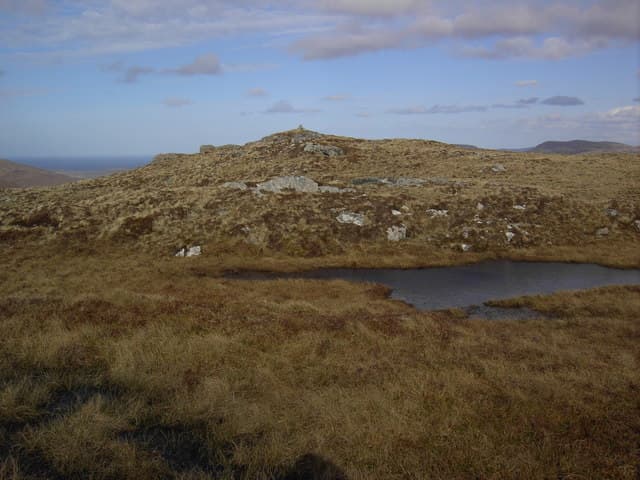
Ghlas-bheinn — the grey-green hill — is a 333m summit at NC 332 614 on the Cape Wrath peninsula east of Loch Eriboll. The Gaelic refers to the pale grey-green colour of its moss and lichen-covered summit slabs, distinct from the heather brown of the surrounding moor.
Gaelic: “grey-green” · Pronunciation: glass bheinn
Quick facts
- Height
- 333m/ 1093ft
- Prominence
- 156 m
- Grid ref
- NC 33221 61437
- Dogs
- Dogs on lead required near livestockDog-friendly guide ↗
Height and prominence cross-checked against the Database of British and Irish Hills (CC BY).
No GPX track yet
Walked this route? Share your track to help other walkers.
Standard route
heather and bog 65% · grass slopes 25% · rocky summit 10%
Approached from the A838 at the head of Loch Eriboll, with a 4km walk-in across moor and bog before the final climb. The summit slabs are obvious on the skyline. A 4-5 hour day.
Terrain
Cambrian quartzite slabs cap a Lewisian gneiss base. The summit is a tilted slab pavement of pale rock heavily colonised by grey-green lichen — the colour that names the hill. Surrounding bog is deep and wet.
In winter
Verglas on the slab summit is the main winter hazard — the smooth quartzite becomes lethally slippery after thaw refreezes. Snow itself is intermittent at this altitude near the coast.
This hill is in the Torridon SAIS forecast area. Check SAIS forecasts in winter (December–April).
Best time of year
Getting there
- Glasgow7h 2m
- Edinburgh8h 55m
OS maps: OS Landranger 9, OS Explorer 446
Mobile signal: Poor. No networks. Carry a personal locator beacon on this remote Sutherland summit.
Current conditions
Daylight Today
- Sunrise
- 05:05
- Sunset
- 21:47
- Civil dawn
- 04:08
- Civil dusk
- 22:43
NOAA Solar Calculator · 30 July 2026
Around Ghlas-bheinn on the SCOT network
Getting there, basing yourself, and what to do off the hill.
Ghlas-bheinn — common questions
- What difficulty is Ghlas-bheinn?
- On the OutdoorSCOT scale, Ghlas-bheinn comes in at 1/5 — easy. Ground conditions: Cambrian quartzite slabs cap a Lewisian gneiss base.
- How much drop does Ghlas-bheinn have?
- The drop is 156m: measured from the summit of Ghlas-bheinn down to the saddle joining it to higher terrain. Passing the 150m-drop threshold on all sides is exactly what makes it a Marilyn.
- What's the best month to climb Ghlas-bheinn?
- Aim for March, April, May, June, July, August, September, October on Ghlas-bheinn. In the remaining months treat it as a winter hill — full kit, solid navigation, and a look at the relevant SAIS avalanche forecast before you go.
- Can dogs go up Ghlas-bheinn?
- Dogs are fine on a lead. The route passes livestock or ground-nesting bird habitat, so keep them close throughout.
- Will I get phone signal on Ghlas-bheinn?
- Poor. No networks. Carry a personal locator beacon on this remote Sutherland summit.
- Is Ghlas-bheinn safe in winter?
- Verglas on the slab summit is the main winter hazard — the smooth quartzite becomes lethally slippery after thaw refreezes. Snow itself is intermittent at this altitude near the coast.
Get the OutdoorSCOT weekly
One email a week — new route, hill and bothy guides, seasonal conditions and the odd hard-won lesson. No spam, unsubscribe in one click.