Marilyn · North-West Highlands
Creag Riabhach
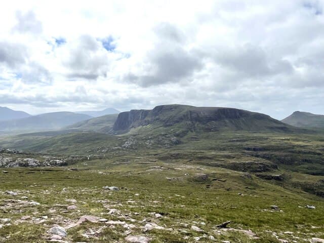
Creag Riabhach — the brindled crag — rises to 485m at NC 278 637 on the Cape Wrath peninsula north of Loch Eriboll. The Gaelic refers to alternating bands of pale quartzite and dark gneiss that streak the summit crag — a striped pattern visible from the road to Durness.
Gaelic: “crag, brindled” · Pronunciation: krayg riabhach
Quick facts
- Height
- 485m/ 1591ft
- Prominence
- 349 m
- Grid ref
- NC 27889 63790
- Dogs
- Dogs on lead required near livestockDog-friendly guide ↗
Height and prominence cross-checked against the Database of British and Irish Hills (CC BY).
No GPX track yet
Walked this route? Share your track to help other walkers.
Standard route
heather moorland 50% · rocky slopes 35% · grass slopes 15%
Approached from the A838 west of Durness, with a 6km walk-in across open moor before the summit pull. There is no path; navigation is by compass and contour. A 6-7 hour day.
Terrain
Lewisian gneiss with Cambrian quartzite caps — the brindle effect comes from the sharp colour change at the contact zone. The summit area is bare rock pavement with cushion plants in the cracks; below is wet flow country.
In winter
The Cape Wrath peninsula is the windiest place in mainland Britain — Farrmheall and Creag Riabhach catch the full force of Atlantic gales. Snow is intermittent; the danger is wind chill and the difficulty of bog navigation in poor visibility.
This hill is in the Torridon SAIS forecast area. Check SAIS forecasts in winter (December–April).
Best time of year
Getting there
- Glasgow7h 8m
- Edinburgh8h 5m
OS maps: OS Landranger 9, OS Explorer 446
Mobile signal: Poor. No coverage on this isolated Sutherland hill; bring paper maps.
Current conditions
Daylight Today
- Sunrise
- 05:05
- Sunset
- 21:47
- Civil dawn
- 04:09
- Civil dusk
- 22:44
NOAA Solar Calculator · 30 July 2026
Around Creag Riabhach on the SCOT network
Getting there, basing yourself, and what to do off the hill.
Creag Riabhach — common questions
- Is Creag Riabhach a hard climb?
- Creag Riabhach is rated 1/5 (easy) on the OutdoorSCOT scale. Terrain: Lewisian gneiss with Cambrian quartzite caps — the brindle effect comes from the sharp colour change at the contact zone.
- How prominent is Creag Riabhach?
- Creag Riabhach has 349m of topographic prominence — the height of its summit above the highest col connecting it to higher ground. Marilyns are defined by that measure: at least 150m of drop on all sides.
- When should I climb Creag Riabhach?
- The standard good-weather months for Creag Riabhach are March, April, May, June, July, August, September, October. Outside those months, expect winter conditions on the high ground — full mountain kit, navigation skills, and a check of the SAIS avalanche forecast for the relevant region.
- Can I bring my dog up Creag Riabhach?
- On a lead only — the route crosses ground with livestock or nesting-bird interest.
- What's mobile reception like on Creag Riabhach?
- Poor. No coverage on this isolated Sutherland hill; bring paper maps.
- Is Creag Riabhach safe in winter?
- The Cape Wrath peninsula is the windiest place in mainland Britain — Farrmheall and Creag Riabhach catch the full force of Atlantic gales. Snow is intermittent; the danger is wind chill and the difficulty of bog navigation in poor visibility.
Get the OutdoorSCOT weekly
One email a week — new route, hill and bothy guides, seasonal conditions and the odd hard-won lesson. No spam, unsubscribe in one click.