Marilyn · North-West Highlands
Beinn Akie
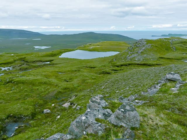
Beinn Akie is a quiet 288m bump in the NC34 grid square on the Cape Wrath peninsula, looking out across the Kyle of Durness towards Faraid Head. Despite the height, it is one of the most isolated summits in mainland Britain.
Quick facts
- Height
- 288m/ 945ft
- Prominence
- 161 m
- Grid ref
- NC 34089 64994
- Dogs
- Dogs on lead required near livestockDog-friendly guide ↗
Height and prominence cross-checked against the Database of British and Irish Hills (CC BY).
No GPX track yet
Walked this route? Share your track to help other walkers.
Standard route
blanket bog 55% · heather moorland 30% · rocky summit 15%
There is no path. Start from the A838 near Keoldale, cross the rough ground above Daill Bay and follow the gentle southwest spur to the cairn. Round trip typically 2-3 hours of pathless walking.
Terrain
Lewisian gneiss outcrops emerge from spongy peat and sphagnum-rich hollows. The Cape Wrath bombing range lies nearby; check live firing notices before setting out.
In winter
Wild Atlantic gales scour the peninsula and horizontal sleet is common. Snow rarely settles for long but iced peat hags can be treacherous when wind-glazed.
This hill is in the Torridon SAIS forecast area. Check SAIS forecasts in winter (December–April).
Best time of year
Getting there
- Glasgow7h 7m
- Edinburgh8h 58m
OS maps: OS Landranger 9, OS Explorer 446
Mobile signal: Poor. Dead zone; even roaming signals fail here in the far north.
Current conditions
Daylight Today
- Sunrise
- 05:05
- Sunset
- 21:47
- Civil dawn
- 04:08
- Civil dusk
- 22:44
NOAA Solar Calculator · 30 July 2026
Around Beinn Akie on the SCOT network
Getting there, basing yourself, and what to do off the hill.
Beinn Akie — common questions
- Is Beinn Akie a hard climb?
- Beinn Akie is rated 1/5 (easy) on the OutdoorSCOT scale. Terrain: Lewisian gneiss outcrops emerge from spongy peat and sphagnum-rich hollows.
- How prominent is Beinn Akie?
- Beinn Akie has 161m of topographic prominence — the height of its summit above the highest col connecting it to higher ground. Marilyns are defined by that measure: at least 150m of drop on all sides.
- When should I climb Beinn Akie?
- The standard good-weather months for Beinn Akie are March, April, May, June, July, August, September, October. Outside those months, expect winter conditions on the high ground — full mountain kit, navigation skills, and a check of the SAIS avalanche forecast for the relevant region.
- Can I bring my dog up Beinn Akie?
- On a lead only — the route crosses ground with livestock or nesting-bird interest.
- What's mobile reception like on Beinn Akie?
- Poor. Dead zone; even roaming signals fail here in the far north.
- Is Beinn Akie safe in winter?
- Wild Atlantic gales scour the peninsula and horizontal sleet is common. Snow rarely settles for long but iced peat hags can be treacherous when wind-glazed.
Get the OutdoorSCOT weekly
One email a week — new route, hill and bothy guides, seasonal conditions and the odd hard-won lesson. No spam, unsubscribe in one click.