Marilyn · Perthshire
Conic Hill
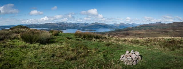
Conic Hill is the iconic 361m cone above Balmaha on the east shore of Loch Lomond, at NS 432 923. It is the most-walked Marilyn in Scotland: the West Highland Way crosses its eastern shoulder, and the line of crags that drops to the loch defines the Highland Boundary Fault. The summit view aligns perfectly with the chain of fault-line islands — Inchcailloch, Torrinch, Creinch and Inchmurrin.
Quick facts
- Height
- 361m/ 1184ft
- Prominence
- 153 m
- Grid ref
- NS 43282 92393
- Nearest city
- Glasgow· 31km
- Dogs
- Dogs on lead required near livestockDog-friendly guide ↗
Height and prominence cross-checked against the Database of British and Irish Hills (CC BY).
No GPX track yet
Walked this route? Share your track to help other walkers.
Standard route
woodland paths 25% · heather moorland 50% · rocky ridge 25%
From the Balmaha National Park visitor centre car park, join the signed West Highland Way north-east through oak woodland, climbing a stepped path to the rocky shoulder. A short branch path swings west off the WHW onto the summit ridge — only the very top is left to the legs.
Terrain
Stone-pitched West Highland Way path through oak and birch on the lower hill, gravelled steps on the steep middle section, and a slightly eroded grass/rock ridge across the summit knolls. Excellent path standard throughout.
In winter
A busy low hill where ice on the stone steps is the major winter risk after a freeze; the path catches every drip from the trees. Snow on the summit cone rarely lies but freezes into hard patches in the corries. Microspikes are recommended December-February.
Best time of year
Getting there
- Glasgow1h 56m
- Edinburgh3h 28m
OS maps: OS Landranger 56, OS Explorer 0038, OS Explorer 347
Mobile signal: Reliable up top; steady on EE and Vodafone. Clear views to Loch Lomond islands.
Current conditions
Daylight Today
- Sunrise
- 05:17
- Sunset
- 21:32
- Civil dawn
- 04:28
- Civil dusk
- 22:21
NOAA Solar Calculator · 30 July 2026
Around Conic Hill on the SCOT network
Getting there, basing yourself, and what to do off the hill.
Getting there: Balloch station
South Loch Lomond — WHW start at Drymen / Conic Hill
11km from the hill
tripscot.co.uk
On TripSCOTBase yourself in Luss
West Loch Lomond village — Highland Boundary, Loch Lomond Way
7km from the hill
tripscot.co.uk
On TasteSCOTAfter the hill: Loch Lomond
Alexandria — sprawling distillery on the south end of the loch
13km from the hill
tastescot.co.uk
Conic Hill — common questions
- What difficulty is Conic Hill?
- On the OutdoorSCOT scale, Conic Hill comes in at 1/5 — easy. Ground conditions: Stone-pitched West Highland Way path through oak and birch on the lower hill, gravelled steps on the steep middle section, and a slightly eroded grass/rock ridge across the summit knolls.
- How much drop does Conic Hill have?
- The drop is 153m: measured from the summit of Conic Hill down to the saddle joining it to higher terrain. Passing the 150m-drop threshold on all sides is exactly what makes it a Marilyn.
- What's the best month to climb Conic Hill?
- Aim for March, April, May, June, July, August, September, October on Conic Hill. In the remaining months treat it as a winter hill — full kit, solid navigation, and a look at the relevant SAIS avalanche forecast before you go.
- Can dogs go up Conic Hill?
- Dogs are fine on a lead. The route passes livestock or ground-nesting bird habitat, so keep them close throughout.
- Will I get phone signal on Conic Hill?
- Reliable up top; steady on EE and Vodafone. Clear views to Loch Lomond islands.
- Is Conic Hill safe in winter?
- A busy low hill where ice on the stone steps is the major winter risk after a freeze; the path catches every drip from the trees. Snow on the summit cone rarely lies but freezes into hard patches in the corries. Microspikes are recommended December-February.
Get the OutdoorSCOT weekly
One email a week — new route, hill and bothy guides, seasonal conditions and the odd hard-won lesson. No spam, unsubscribe in one click.