Marilyn · North-West Highlands
Cnoc an Liath-bhaid Mhoir
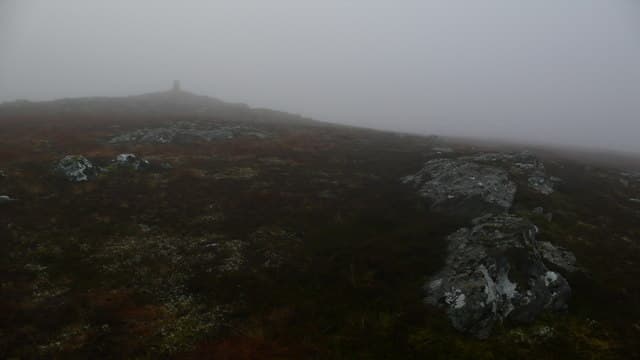
Cnoc an Liath-bhaid Mhoir — "knoll of the big grey clump" — is a 434m heathery rise in the NC75 grid square inland from Loch Naver, near the abandoned settlements of Strath Naver.
Gaelic: “small hill, the, grey” · Pronunciation: k-nok an lee-ah bhaid mhoir
Quick facts
- Height
- 434m/ 1424ft
- Prominence
- 158 m
- Grid ref
- NC 75936 29126
- Nearest city
- Inverness· 84km
- Dogs
- Dogs on lead required near livestockDog-friendly guide ↗
Height and prominence cross-checked against the Database of British and Irish Hills (CC BY).
No GPX track yet
Walked this route? Share your track to help other walkers.
Standard route
blanket bog 55% · heather moorland 30% · grassy summit 15%
Park near Syre in Strath Naver and follow estate tracks east into the open hill, then climb the broad northeast flank to the cairn. Allow 5 hours.
Terrain
A long flat moor approach with grey lichen-spattered boulders giving the hill its name. The summit area is broad and slightly bouldery.
In winter
Frozen ground is a blessing on the long flat approach. Otherwise expect slow progress through wet heather.
This hill is in the Torridon SAIS forecast area. Check SAIS forecasts in winter (December–April).
Best time of year
Getting there
- Glasgow6h 9m
- Edinburgh6h 22m
OS maps: OS Landranger 16, OS Explorer 444W
Mobile signal: Poor. No coverage on this summit; nearest signal near the Kyle of Sutherland.
Current conditions
Daylight Today
- Sunrise
- 05:04
- Sunset
- 21:42
- Civil dawn
- 04:08
- Civil dusk
- 22:38
NOAA Solar Calculator · 30 July 2026
Around Cnoc an Liath-bhaid Mhoir on the SCOT network
Getting there, basing yourself, and what to do off the hill.
Getting there: Helmsdale station
Far North coast; Strath of Kildonan; Flow Country gateway
30km from the hill
tripscot.co.uk
On TripSCOTBase yourself in Durness
Cape Wrath base; Smoo Cave; Sandwood Bay walk-in
52km from the hill
tripscot.co.uk
On TasteSCOTAfter the hill: Clynelish
Brora — waxy, coastal-Highland classic on the Far North line
29km from the hill
tastescot.co.uk
Cnoc an Liath-bhaid Mhoir — common questions
- Is Cnoc an Liath-bhaid Mhoir a hard climb?
- Cnoc an Liath-bhaid Mhoir is rated 1/5 (easy) on the OutdoorSCOT scale. Underfoot: A long flat moor approach with grey lichen-spattered boulders giving the hill its name.
- What is Cnoc an Liath-bhaid Mhoir's prominence?
- 158m of prominence. That's the vertical drop from the summit to the col that links Cnoc an Liath-bhaid Mhoir to the next higher ground. That drop is what qualifies it as a Marilyn — a hill with at least 150m of descent on every side.
- When is the best time to climb Cnoc an Liath-bhaid Mhoir?
- March, April, May, June, July, August, September, October give the most reliable conditions on Cnoc an Liath-bhaid Mhoir. Beyond that window the high ground turns wintry: carry full mountain kit, be confident navigating, and check the SAIS avalanche forecast for the area.
- Is Cnoc an Liath-bhaid Mhoir dog-friendly?
- Yes, but dogs must be kept on a lead — there is livestock or ground-nesting bird interest on the route.
- Is there mobile signal on Cnoc an Liath-bhaid Mhoir?
- Poor. No coverage on this summit; nearest signal near the Kyle of Sutherland.
- Is Cnoc an Liath-bhaid Mhoir safe in winter?
- Frozen ground is a blessing on the long flat approach. Otherwise expect slow progress through wet heather.
Get the OutdoorSCOT weekly
One email a week — new route, hill and bothy guides, seasonal conditions and the odd hard-won lesson. No spam, unsubscribe in one click.