Marilyn · Skye & The Small Isles
Carn a' Ghaill
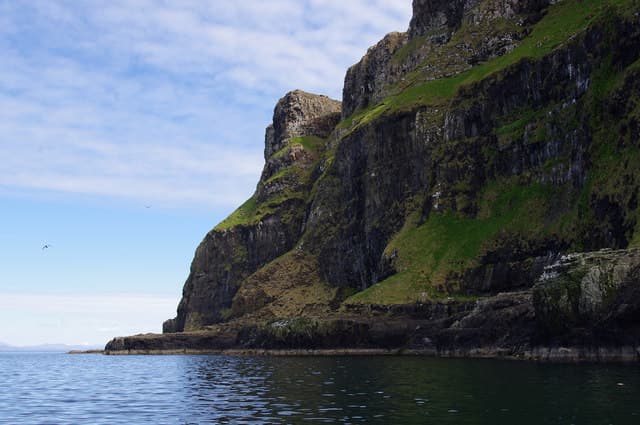
Carn a' Ghaill — Cairn of the Strangers — is the western summit of the Isle of Canna, sitting on the magnetic basalt that gives nearby Compass Hill its name. At 211m it is a modest top but the prominence above the surrounding cliffs makes it a true Marilyn with an outsized horizon.
Quick facts
- Height
- 211m/ 692ft
- Prominence
- 211 m
- Grid ref
- NG 26382 06442
- Dogs
- Dogs on lead required near livestockDog-friendly guide ↗
Height and prominence cross-checked against the Database of British and Irish Hills (CC BY).
No GPX track yet
Walked this route? Share your track to help other walkers.
Standard route
heather moorland 55% · rocky slopes 30% · grass slopes 15%
From Canna Pier walk the rough track west past Coroghon to the open ground beneath Compass Hill, then climb directly north-west to the cairn. The going is short but exposed, and the cliffs on the seaward side demand respect. Expect 2 hours return at a steady pace.
Terrain
Cropped sheep pasture on the lower ground gives way to bare basalt and short heath near the summit. Local lore notes that compasses deflect on the magnetic rock — do not rely solely on a needle for navigation here.
In winter
Wet rather than snowy in winter, with prolonged gales that can pin the ferry in Mallaig. Useful for hill-walking when the Cuillin are sheathed in ice.
Best time of year
Getting there
- Glasgow7h 38m
- Edinburgh9h 5m
Ferry access
Mallaig → Canna (via Rum and Eigg)
- Crossing time195 min
- Summer sailings2–3 sailings per week (Apr–Oct)
- Winter sailings1–2 sailings per week (Nov–Mar)
- Book ahead21 days
One of Scotland's most remote ferry destinations — over 3 hours each way. Overnight stay essential. Very limited supplies on the island; bring all food.
Book on CalMac ↗OS maps: OS Landranger 39, OS Explorer 397
Mobile signal: Poor. Inner Hebrides island; no EE or Vodafone signal on this summit.
Current conditions
Daylight Today
- Sunrise
- 05:20
- Sunset
- 21:45
- Civil dawn
- 04:28
- Civil dusk
- 22:37
NOAA Solar Calculator · 30 July 2026
Around Carn a' Ghaill on the SCOT network
Getting there, basing yourself, and what to do off the hill.
Getting there: Mallaig station
End of the Road to the Isles — ferry to Skye, Knoydart, Small Isles
42km from the hill
tripscot.co.uk
On TripSCOTBase yourself in Mallaig
Ferry port for Skye and the Small Isles; CWT finish supply
42km from the hill
tripscot.co.uk
On TasteSCOTAfter the hill: Talisker
Carbost on Skye — Cuillin foothills distillery; peppery, maritime, big-bodied
28km from the hill
tastescot.co.uk
Carn a' Ghaill — common questions
- How difficult is Carn a' Ghaill?
- Carn a' Ghaill carries a 1/5 (easy) grade on the OutdoorSCOT scale. Ground conditions: Cropped sheep pasture on the lower ground gives way to bare basalt and short heath near the summit.
- How much drop does Carn a' Ghaill have?
- Carn a' Ghaill's prominence is its full height — 211m — because it is the highest point of its landmass, with no higher ground connected to it. Passing the 150m-drop threshold on all sides is exactly what makes it a Marilyn.
- What's the best month to climb Carn a' Ghaill?
- Aim for March, April, May, June, July, August, September, October on Carn a' Ghaill. In the remaining months treat it as a winter hill — full kit, solid navigation, and a look at the relevant SAIS avalanche forecast before you go.
- Can dogs go up Carn a' Ghaill?
- Dogs are fine on a lead. The route passes livestock or ground-nesting bird habitat, so keep them close throughout.
- Will I get phone signal on Carn a' Ghaill?
- Poor. Inner Hebrides island; no EE or Vodafone signal on this summit.
- How do I get the ferry to Carn a' Ghaill?
- Mallaig → Canna (via Rum and Eigg). 2–3 sailings per week (Apr–Oct) in summer; 1–2 sailings per week (Nov–Mar) in winter. Book at least 21 days ahead. One of Scotland's most remote ferry destinations — over 3 hours each way. Overnight stay essential. Very limited supplies on the island; bring all food.
- Is Carn a' Ghaill safe in winter?
- Wet rather than snowy in winter, with prolonged gales that can pin the ferry in Mallaig. Useful for hill-walking when the Cuillin are sheathed in ice.
Get the OutdoorSCOT weekly
One email a week — new route, hill and bothy guides, seasonal conditions and the odd hard-won lesson. No spam, unsubscribe in one click.