Marilyn · North-West Highlands
Breac-Bheinn
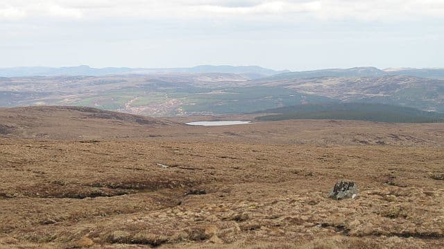
Breac-Bheinn — the speckled hill — is a 464m summit at NH 498 950 east of Bonar Bridge. The Gaelic refers to a mottled pattern of pale quartzite blocks scattered across darker schist — a glacial scattering visible from miles around when the light catches them.
Quick facts
- Height
- 464m/ 1522ft
- Prominence
- 159 m
- Grid ref
- NH 49811 95078
- Nearest city
- Inverness· 52km
- Dogs
- Dogs on lead required near livestockDog-friendly guide ↗
Height and prominence cross-checked against the Database of British and Irish Hills (CC BY).
No GPX track yet
Walked this route? Share your track to help other walkers.
Standard route
heather moorland 55% · rocky slopes 30% · grass slopes 15%
An easy outing from the minor road past Croick church, with a track running west to within a kilometre of the summit. The final climb is short heather and grass. About 3 hours round trip.
Terrain
Moine schist studded with quartzite erratics — the speckle of the name. The summit area is open grass with the pale blocks scattered like sheep across the dome; the lower slopes are heather and bog.
In winter
A low east-coast hill with limited snow cover. Drains quickly and dries early; useful as a winter half-day when the higher hills are out of condition. The quartzite blocks become reliable navigation marks in light snow.
This hill is in the Torridon SAIS forecast area. Check SAIS forecasts in winter (December–April).
Best time of year
Getting there
- Glasgow5h 23m
- Edinburgh6h 10m
OS maps: OS Landranger 20, OS Explorer 440S, OS Explorer 441W
Mobile signal: Poor. Remote Sutherland or Argyll; limited coverage.
Current conditions
Daylight Today
- Sunrise
- 05:07
- Sunset
- 21:42
- Civil dawn
- 04:13
- Civil dusk
- 22:37
NOAA Solar Calculator · 30 July 2026
Around Breac-Bheinn on the SCOT network
Getting there, basing yourself, and what to do off the hill.
Getting there: Ardgay station
Kyle of Sutherland; Croick; Far North Line
11km from the hill
tripscot.co.uk
On TripSCOTBase yourself in Ullapool
Main NW Highlands hub; Hebrides ferry; Inverpolly access
37km from the hill
tripscot.co.uk
On TasteSCOTAfter the hill: Balblair
Edderton — Easter Ross distillery with vintage-led range
23km from the hill
tastescot.co.uk
Breac-Bheinn — common questions
- How difficult is Breac-Bheinn?
- Breac-Bheinn carries a 1/5 (easy) grade on the OutdoorSCOT scale. Underfoot: Moine schist studded with quartzite erratics — the speckle of the name.
- What is Breac-Bheinn's prominence?
- 159m of prominence. That's the vertical drop from the summit to the col that links Breac-Bheinn to the next higher ground. That drop is what qualifies it as a Marilyn — a hill with at least 150m of descent on every side.
- When is the best time to climb Breac-Bheinn?
- March, April, May, June, July, August, September, October give the most reliable conditions on Breac-Bheinn. Beyond that window the high ground turns wintry: carry full mountain kit, be confident navigating, and check the SAIS avalanche forecast for the area.
- Is Breac-Bheinn dog-friendly?
- Yes, but dogs must be kept on a lead — there is livestock or ground-nesting bird interest on the route.
- Is there mobile signal on Breac-Bheinn?
- Poor. Remote Sutherland or Argyll; limited coverage.
- Is Breac-Bheinn safe in winter?
- A low east-coast hill with limited snow cover. Drains quickly and dries early; useful as a winter half-day when the higher hills are out of condition. The quartzite blocks become reliable navigation marks in light snow.
Get the OutdoorSCOT weekly
One email a week — new route, hill and bothy guides, seasonal conditions and the odd hard-won lesson. No spam, unsubscribe in one click.