Marilyn · Skye
Biod an Athair
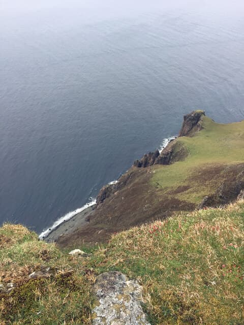
Biod an Athair — the Air Point — is the highest sea-cliff on Skye, the NG 15 54 grid putting its 314m summit directly above the Atlantic on the Duirinish peninsula north-west of Dunvegan. The cliff falls almost 300m sheer to the sea, making this one of the most dramatic coastal summits in Britain.
Quick facts
- Height
- 314m/ 1030ft
- Prominence
- 178 m
- Grid ref
- NG 15832 54936
- Dogs
- Dogs on lead required near livestockDog-friendly guide ↗
Height and prominence cross-checked against the Database of British and Irish Hills (CC BY).
No GPX track yet
Walked this route? Share your track to help other walkers.
Standard route
grass slopes 55% · rocky cliffs 30% · heather patches 15%
From Lorgill (NG 17 39) or the road end at Ramasaig follow rough sheep paths north across open moor to gain the clifftop, then walk north along the rim to the trig point. Around 9 km return with 360m of climb — but allow extra time for the cliff-edge scenery.
Terrain
Boggy moorland on the approach with short close-cropped sheep turf along the cliff edge. The cliff is overhanging in places and the grass edge can break away — keep well back.
In winter
Snow rarely lies at this elevation but the cliff edge becomes lethal in any frost. Atlantic gales here are extreme and have lifted walkers off their feet — pick a settled day.
Best time of year
Getting there
- Glasgow8h 43m
- Edinburgh10h 2m
OS maps: OS Landranger 23, OS Explorer 407
Mobile signal: Poor. Remote Skye Trotternish; limited coverage.
Current conditions
Daylight Today
- Sunrise
- 05:19
- Sunset
- 21:48
- Civil dawn
- 04:25
- Civil dusk
- 22:42
NOAA Solar Calculator · 30 July 2026
Around Biod an Athair on the SCOT network
Getting there, basing yourself, and what to do off the hill.
Biod an Athair — common questions
- How difficult is Biod an Athair?
- Biod an Athair carries a 1/5 (easy) grade on the OutdoorSCOT scale. Ground conditions: Boggy moorland on the approach with short close-cropped sheep turf along the cliff edge.
- How much drop does Biod an Athair have?
- The drop is 178m: measured from the summit of Biod an Athair down to the saddle joining it to higher terrain. Passing the 150m-drop threshold on all sides is exactly what makes it a Marilyn.
- What's the best month to climb Biod an Athair?
- Aim for March, April, May, June, July, August, September, October on Biod an Athair. In the remaining months treat it as a winter hill — full kit, solid navigation, and a look at the relevant SAIS avalanche forecast before you go.
- Can dogs go up Biod an Athair?
- Dogs are fine on a lead. The route passes livestock or ground-nesting bird habitat, so keep them close throughout.
- Will I get phone signal on Biod an Athair?
- Poor. Remote Skye Trotternish; limited coverage.
- Is Biod an Athair safe in winter?
- Snow rarely lies at this elevation but the cliff edge becomes lethal in any frost. Atlantic gales here are extreme and have lifted walkers off their feet — pick a settled day.
Get the OutdoorSCOT weekly
One email a week — new route, hill and bothy guides, seasonal conditions and the odd hard-won lesson. No spam, unsubscribe in one click.