Marilyn · Skye
Beinn Chreagach
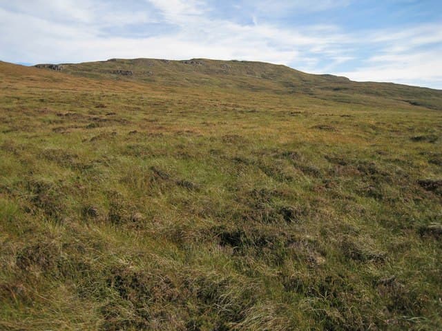
Beinn Chreagach — the Rocky Hill — rises in the middle of the Waternish peninsula in north-west Skye. The NG 28 53 grid puts it on the high ground between Loch Bay and Loch Snizort, overlooking the village of Stein and the romantic outline of Dunvegan Castle to the south.
Quick facts
- Height
- 326m/ 1070ft
- Prominence
- 220 m
- Grid ref
- NG 28911 53428
- Dogs
- Dogs on lead required near livestockDog-friendly guide ↗
Height and prominence cross-checked against the Database of British and Irish Hills (CC BY).
No GPX track yet
Walked this route? Share your track to help other walkers.
Standard route
heather moorland 50% · rocky slopes 35% · grass slopes 15%
Park at Geary (NG 26 60) or near Trumpan church and head south-east up the open hillside. The summit is a rocky knot with a small cairn and views across to MacLeod's Tables. About 7 km return with 280m of climb.
Terrain
Heather and tussocky grass with frequent basalt outcrops giving the hill its Gaelic name. The going is reasonable on the upper plateau but boggy through the lower fields.
In winter
Sea-level base means snow rarely settles for long. The exposed top catches the full Minch wind and rain-frozen rock makes the summit cap awkward in cold conditions.
Best time of year
Getting there
- Glasgow7h 14m
- Edinburgh10h 30m
OS maps: OS Landranger 23, OS Explorer 407
Mobile signal: Poor. Remote Skye or Inner Hebrides; limited coverage.
Current conditions
Daylight Today
- Sunrise
- 05:18
- Sunset
- 21:47
- Civil dawn
- 04:24
- Civil dusk
- 22:41
NOAA Solar Calculator · 30 July 2026
Around Beinn Chreagach on the SCOT network
Getting there, basing yourself, and what to do off the hill.
Getting there: Kyle of Lochalsh station
Skye Bridge; Five Sisters of Kintail; Glen Shiel; Plockton
54km from the hill
tripscot.co.uk
On TripSCOTBase yourself in Portree
Main Skye base — Cuillin, Trotternish, Storr
21km from the hill
tripscot.co.uk
On TasteSCOTAfter the hill: Talisker
Carbost on Skye — Cuillin foothills distillery; peppery, maritime, big-bodied
23km from the hill
tastescot.co.uk
Beinn Chreagach — common questions
- Is Beinn Chreagach a hard climb?
- Beinn Chreagach is rated 1/5 (easy) on the OutdoorSCOT scale. Ground conditions: Heather and tussocky grass with frequent basalt outcrops giving the hill its Gaelic name.
- How much drop does Beinn Chreagach have?
- The drop is 220m: measured from the summit of Beinn Chreagach down to the saddle joining it to higher terrain. Passing the 150m-drop threshold on all sides is exactly what makes it a Marilyn.
- What's the best month to climb Beinn Chreagach?
- Aim for March, April, May, June, July, August, September, October on Beinn Chreagach. In the remaining months treat it as a winter hill — full kit, solid navigation, and a look at the relevant SAIS avalanche forecast before you go.
- Can dogs go up Beinn Chreagach?
- Dogs are fine on a lead. The route passes livestock or ground-nesting bird habitat, so keep them close throughout.
- Will I get phone signal on Beinn Chreagach?
- Poor. Remote Skye or Inner Hebrides; limited coverage.
- Is Beinn Chreagach safe in winter?
- Sea-level base means snow rarely settles for long. The exposed top catches the full Minch wind and rain-frozen rock makes the summit cap awkward in cold conditions.
Get the OutdoorSCOT weekly
One email a week — new route, hill and bothy guides, seasonal conditions and the odd hard-won lesson. No spam, unsubscribe in one click.