Marilyn · Galloway
Benbeoch
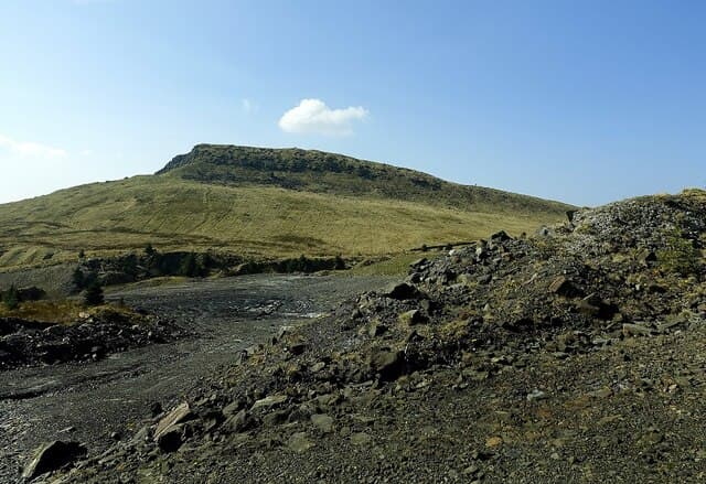
Benbeoch rises to 463m on the NS-square ridge above Dalmellington, an East Ayrshire summit best known for the dramatic basalt cliff that drops to the Doon valley below. The crag gives the hill a profile far bigger than its height.
Quick facts
- Height
- 463m/ 1519ft
- Prominence
- 160 m
- Grid ref
- NS 49549 08293
- Nearest city
- Dumfries· 58km
- Dogs
- Dogs on lead required near livestockDog-friendly guide ↗
Height and prominence cross-checked against the Database of British and Irish Hills (CC BY).
No GPX track yet
Walked this route? Share your track to help other walkers.
Standard route
heather moorland 60% · grass slopes 30% · rocky summit 10%
Start from Burnton near Dalmellington and follow forestry edges onto the western slopes, then bear up grass and heather to the rim above the cliff. Two hours covers the walk; keep well clear of the eastern edge in wind.
Terrain
Grass slopes and bracken on the western flank, with crags and loose basalt forming the dramatic eastern wall. The summit itself is grassy.
In winter
Verglas on the cliff-edge rocks is a hazard worth respecting. Otherwise the hill stays snow-free most winters and is a good short outing in poor weather.
Best time of year
Getting there
- Glasgow1h 22m
- Edinburgh3h 26m
OS maps: OS Landranger 70, OS Landranger 77, OS Explorer 327
Mobile signal: Good. East Ayrshire; EE and Vodafone reliable on this summit.
Current conditions
Daylight Today
- Sunrise
- 05:21
- Sunset
- 21:27
- Civil dawn
- 04:33
- Civil dusk
- 22:15
NOAA Solar Calculator · 30 July 2026
Around Benbeoch on the SCOT network
Getting there, basing yourself, and what to do off the hill.
Benbeoch — common questions
- What difficulty is Benbeoch?
- On the OutdoorSCOT scale, Benbeoch comes in at 1/5 — easy. Underfoot: Grass slopes and bracken on the western flank, with crags and loose basalt forming the dramatic eastern wall.
- What is Benbeoch's prominence?
- 160m of prominence. That's the vertical drop from the summit to the col that links Benbeoch to the next higher ground. That drop is what qualifies it as a Marilyn — a hill with at least 150m of descent on every side.
- When is the best time to climb Benbeoch?
- March, April, May, June, July, August, September, October give the most reliable conditions on Benbeoch. Beyond that window the high ground turns wintry: carry full mountain kit, be confident navigating, and check the SAIS avalanche forecast for the area.
- Is Benbeoch dog-friendly?
- Yes, but dogs must be kept on a lead — there is livestock or ground-nesting bird interest on the route.
- Is there mobile signal on Benbeoch?
- Good. East Ayrshire; EE and Vodafone reliable on this summit.
- Is Benbeoch safe in winter?
- Verglas on the cliff-edge rocks is a hazard worth respecting. Otherwise the hill stays snow-free most winters and is a good short outing in poor weather.
Get the OutdoorSCOT weekly
One email a week — new route, hill and bothy guides, seasonal conditions and the odd hard-won lesson. No spam, unsubscribe in one click.