Marilyn · Galloway
Craiglee
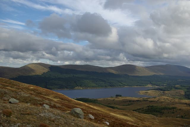
The northern Craiglee, a 523m heather top at NX 47 above the Water of Girvan east of Straiton. This is the lonelier of the two Galloway Craiglees, with views over Loch Bradan and the headwaters of the Stinchar.
Quick facts
- Height
- 523m/ 1716ft
- Grid ref
- NX 47078 96245
- Nearest city
- Dumfries· 54km
- Dogs
- Dogs on lead required near livestockDog-friendly guide ↗
No GPX track yet
Walked this route? Share your track to help other walkers.
Standard route
heather moorland 60% · boggy ground 25% · grassy summit 15%
From the road end near Tairlaw, follow the forestry track south-east before breaking out onto open ground for the final heather pull to the cairn. Allow 2 to 3 hours for the round trip from Straiton.
Terrain
Forest track approach then knee-deep heather and peat hags on the summit dome. Stick to the highest ground in mist to avoid the wettest sections.
In winter
Snow lies only briefly at this elevation; the bigger winter issue is bog and standing water on the peaty top. Gaiters are useful from October onward.
Best time of year
Getting there
- Glasgow2h 39m
- Edinburgh4h 39m
OS maps: OS Landranger 77, OS Explorer 318
Mobile signal: Poor. Signal absent throughout; Galloway moorland has very limited infrastructure.
Current conditions
Daylight Today
- Sunrise
- 04:39
- Sunset
- 22:03
- Civil dawn
- 03:40
- Civil dusk
- 23:01
NOAA Solar Calculator · 27 June 2026
Around Craiglee on the SCOT network
Getting there, basing yourself, and what to do off the hill.
Craiglee — common questions
- How hard is Craiglee?
- Craiglee is rated 2/5 (moderate) on the OutdoorSCOT scale. Terrain: Forest track approach then knee-deep heather and peat hags on the summit dome.
- When is the best time to climb Craiglee?
- The standard good-weather months for Craiglee are March, April, May, June, July, August, September, October. Outside those months, expect winter conditions on the high ground — full mountain kit, navigation skills, and a check of the SAIS avalanche forecast for the relevant region.
- Can I bring my dog up Craiglee?
- Yes, but dogs must be kept on a lead — there is livestock or ground-nesting bird interest on the route.
- Is there mobile signal on Craiglee?
- Poor. Signal absent throughout; Galloway moorland has very limited infrastructure.
- Is Craiglee safe in winter?
- Snow lies only briefly at this elevation; the bigger winter issue is bog and standing water on the peaty top. Gaiters are useful from October onward.
Get the OutdoorSCOT weekly
One email a week — new route, hill and bothy guides, seasonal conditions and the odd hard-won lesson. No spam, unsubscribe in one click.