Marilyn · Ochils
Ben Clach
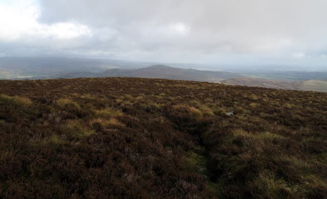
Ben Clach — the stone hill — is the easternmost summit of the Ochil chain, rising to 533m above the Allan Water at NN 759 152. To the north it falls sharply into Glen Eagles; to the south the grass slopes roll down towards Blackford and the A9. Despite proximity to the road, the summit feels remote and is rarely busy.
Quick facts
- Height
- 533.1m/ 1749ft
- Prominence
- 230 m
- Grid ref
- NN 75932 15227
- Nearest city
- Stirling· 22km
- Dogs
- Dogs on lead required near livestockDog-friendly guide ↗
Height and prominence cross-checked against the Database of British and Irish Hills (CC BY).
No GPX track yet
Walked this route? Share your track to help other walkers.
Standard route
heather moorland 65% · grass slopes 25% · rocky summit 10%
A typical line begins at the layby near Easter Glentye on the minor road north of Blackford, following the burn into the grassy bowl beneath the hill then climbing west onto the broad summit ridge. The OS pillar lies on the highest of three rises along the crest.
Terrain
Pure rolling Ochil grassland — short cropped turf above the burns and tussock on the flat summit. Boggy patches in the saddles after rain; the rest drains quickly thanks to underlying volcanic rock.
In winter
Spindrift snow that comes and goes through the cold months; deeper accumulations sometimes lurk in the north-facing scoops above Glen Eagles. The main hazard is hard frozen tussock and disorientation in low cloud — there are few features to fix a bearing on.
Best time of year
Getting there
- Glasgow1h 19m
- Edinburgh2h 18m
OS maps: OS Landranger 57, OS Explorer 047W, OS Explorer 368W
Mobile signal: Moderate. EE intermittent up top; improves toward Callander.
Current conditions
Daylight Today
- Sunrise
- 05:14
- Sunset
- 21:31
- Civil dawn
- 04:24
- Civil dusk
- 22:21
NOAA Solar Calculator · 30 July 2026
Around Ben Clach on the SCOT network
Getting there, basing yourself, and what to do off the hill.
Getting there: Dunblane station
Stirling-area; Sheriffmuir; gateway north
15km from the hill
tripscot.co.uk
On TripSCOTBase yourself in Callander
Trossachs gateway — Ben Ledi, Stuc a Chroin, Rob Roy Way
15km from the hill
tripscot.co.uk
On TasteSCOTAfter the hill: The Glenturret
Crieff — Scotland's oldest working distillery; Famous Grouse Experience
11km from the hill
tastescot.co.uk
Ben Clach — common questions
- Is Ben Clach a hard climb?
- Ben Clach is rated 2/5 (moderate) on the OutdoorSCOT scale. Terrain: Pure rolling Ochil grassland — short cropped turf above the burns and tussock on the flat summit.
- How prominent is Ben Clach?
- Ben Clach has 230m of topographic prominence — the height of its summit above the highest col connecting it to higher ground. Marilyns are defined by that measure: at least 150m of drop on all sides.
- When should I climb Ben Clach?
- The standard good-weather months for Ben Clach are March, April, May, June, July, August, September, October. Outside those months, expect winter conditions on the high ground — full mountain kit, navigation skills, and a check of the SAIS avalanche forecast for the relevant region.
- Can I bring my dog up Ben Clach?
- On a lead only — the route crosses ground with livestock or nesting-bird interest.
- What's mobile reception like on Ben Clach?
- Moderate. EE intermittent up top; improves toward Callander.
- Is Ben Clach safe in winter?
- Spindrift snow that comes and goes through the cold months; deeper accumulations sometimes lurk in the north-facing scoops above Glen Eagles. The main hazard is hard frozen tussock and disorientation in low cloud — there are few features to fix a bearing on.
Get the OutdoorSCOT weekly
One email a week — new route, hill and bothy guides, seasonal conditions and the odd hard-won lesson. No spam, unsubscribe in one click.