Marilyn · Cairngorms
Ben Aigan
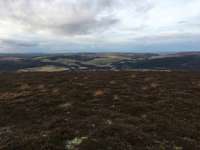
A 471m forested hill above the lower Spey near Fochabers — a Marilyn that doubles as one of Moray's most popular mountain-bike venues. The trig pillar pokes above the conifers and gives a sweeping view of the silver Spey winding to the Moray Firth.
Quick facts
- Height
- 471m/ 1545ft
- Prominence
- 289 m
- Grid ref
- NJ 30971 48142
- Nearest city
- Inverness· 64km
- Dogs
- Dogs on lead required near livestockDog-friendly guide ↗
Height and prominence cross-checked against the Database of British and Irish Hills (CC BY).
No GPX track yet
Walked this route? Share your track to help other walkers.
Standard route
forestry tracks 30% · heather moorland 45% · rocky summit 25%
A network of Forestry and Land Scotland tracks gives several options; the most direct is from the Aigan car park on the A95, following waymarked routes for around 6km return with 350m of ascent. Allow two and a half hours.
Terrain
Forestry roads and well-maintained bike trails the whole way; firm gravel underfoot. Watch for fast descending cyclists at trail junctions.
In winter
Sheltered enough that snow rarely lingers but the forestry roads ice readily. Logging operations continue through winter — heed signs and avoid active blocks.
This hill is in the Northern Cairngorms SAIS forecast area. Check SAIS forecasts in winter (December–April).
Best time of year
Getting there
- Glasgow5h 8m
- Edinburgh4h 3m
OS maps: OS Landranger 28, OS Explorer 424S
Mobile signal: Solid summit coverage; EE seldom drops. Fine Spey valley viewpoint above Fochabers.
Current conditions
Daylight Today
- Sunrise
- 05:04
- Sunset
- 21:34
- Civil dawn
- 04:11
- Civil dusk
- 22:27
NOAA Solar Calculator · 30 July 2026
Around Ben Aigan on the SCOT network
Getting there, basing yourself, and what to do off the hill.
Getting there: Aviemore station
Cairngorm plateau; Lairig Ghru; Speyside Way; Glenmore
54km from the hill
tripscot.co.uk
On TripSCOTBase yourself in Dufftown
Speyside whisky town in the eastern Cairngorms
8km from the hill
tripscot.co.uk
On TasteSCOTAfter the hill: Glen Grant
Rothes — Victorian distillery with celebrated gardens; light-and-floral house style
3km from the hill
tastescot.co.uk
Ben Aigan — common questions
- What difficulty is Ben Aigan?
- On the OutdoorSCOT scale, Ben Aigan comes in at 1/5 — easy. Underfoot: Forestry roads and well-maintained bike trails the whole way; firm gravel underfoot.
- What is Ben Aigan's prominence?
- 289m of prominence. That's the vertical drop from the summit to the col that links Ben Aigan to the next higher ground. That drop is what qualifies it as a Marilyn — a hill with at least 150m of descent on every side.
- When is the best time to climb Ben Aigan?
- March, April, May, June, July, August, September, October give the most reliable conditions on Ben Aigan. Beyond that window the high ground turns wintry: carry full mountain kit, be confident navigating, and check the SAIS avalanche forecast for the area.
- Is Ben Aigan dog-friendly?
- Yes, but dogs must be kept on a lead — there is livestock or ground-nesting bird interest on the route.
- Is there mobile signal on Ben Aigan?
- Solid summit coverage; EE seldom drops. Fine Spey valley viewpoint above Fochabers.
- Is Ben Aigan safe in winter?
- Sheltered enough that snow rarely lingers but the forestry roads ice readily. Logging operations continue through winter — heed signs and avoid active blocks.
Get the OutdoorSCOT weekly
One email a week — new route, hill and bothy guides, seasonal conditions and the odd hard-won lesson. No spam, unsubscribe in one click.