Marilyn · Outer Hebrides
Beinn Mholach
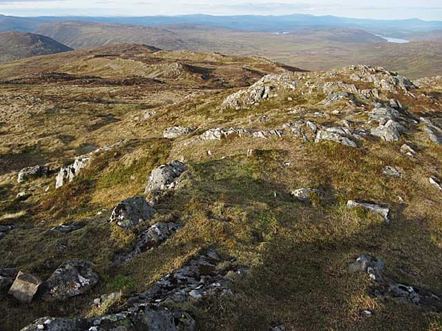
Beinn Mholach — the Shaggy Hill — is a 292m heather and bog summit marooned in the great central moor of Lewis between Stornoway and the north coast. It is the high point of one of the largest expanses of blanket bog in Europe.
Quick facts
- Height
- 292m/ 958ft
- Prominence
- 253 m
- Grid ref
- NB 35563 38707
- Dogs
- Dogs on lead required near livestockDog-friendly guide ↗
Height and prominence cross-checked against the Database of British and Irish Hills (CC BY).
No GPX track yet
Walked this route? Share your track to help other walkers.
Standard route
blanket bog 50% · Lewisian gneiss 35% · rocky summit 15%
A pathless 10-14km round from the A858 at Achmore or from minor roads near North Tolsta, often 5-7 hours depending on conditions. Bring waterproof footwear and a compass for the featureless moor.
Terrain
Vast peat bog, peat hags up to two metres deep, and gneiss outcrops scattered across the plateau. The summit itself is a low rocky knoll. Almost no shelter anywhere on route.
In winter
Saturated peat freezes hard in a real cold snap, briefly making the bog walking easier, but more often the ground is simply wet. Wind exposure across the open moor is severe.
Best time of year
Getting there
- Glasgow9h 31m
- Edinburgh10h 28m
Ferry access
Ullapool → Stornoway (Lewis)
- Crossing time165 min
- Summer sailings2 sailings daily (Apr–Oct)
- Winter sailings1 sailing daily (Nov–Mar)
- Book ahead14 days
- Last ferry backCheck CalMac timetable
Allow 1–2 hours drive from Stornoway to reach the Harris hills. For South Harris hills, Uig → Tarbert may be more convenient.
Book on CalMac ↗OS maps: OS Landranger 8, OS Explorer 459W
Mobile signal: Poor. No carrier reaches this summit; download maps in Stornoway before leaving.
Current conditions
Daylight Today
- Sunrise
- 05:13
- Sunset
- 21:52
- Civil dawn
- 04:17
- Civil dusk
- 22:48
NOAA Solar Calculator · 30 July 2026
Around Beinn Mholach on the SCOT network
Getting there, basing yourself, and what to do off the hill.
Beinn Mholach — common questions
- Is Beinn Mholach a hard climb?
- Beinn Mholach is rated 2/5 (moderate) on the OutdoorSCOT scale. Ground conditions: Vast peat bog, peat hags up to two metres deep, and gneiss outcrops scattered across the plateau.
- How much drop does Beinn Mholach have?
- The drop is 253m: measured from the summit of Beinn Mholach down to the saddle joining it to higher terrain. Passing the 150m-drop threshold on all sides is exactly what makes it a Marilyn.
- What's the best month to climb Beinn Mholach?
- Aim for April, May, June, July, August, September on Beinn Mholach. In the remaining months treat it as a winter hill — full kit, solid navigation, and a look at the relevant SAIS avalanche forecast before you go.
- Can dogs go up Beinn Mholach?
- Dogs are fine on a lead. The route passes livestock or ground-nesting bird habitat, so keep them close throughout.
- Will I get phone signal on Beinn Mholach?
- Poor. No carrier reaches this summit; download maps in Stornoway before leaving.
- How do I get the ferry to Beinn Mholach?
- Ullapool → Stornoway (Lewis). 2 sailings daily (Apr–Oct) in summer; 1 sailing daily (Nov–Mar) in winter. Book at least 14 days ahead. Allow 1–2 hours drive from Stornoway to reach the Harris hills. For South Harris hills, Uig → Tarbert may be more convenient.
- Is Beinn Mholach safe in winter?
- Saturated peat freezes hard in a real cold snap, briefly making the bog walking easier, but more often the ground is simply wet. Wind exposure across the open moor is severe.
Get the OutdoorSCOT weekly
One email a week — new route, hill and bothy guides, seasonal conditions and the odd hard-won lesson. No spam, unsubscribe in one click.