Marilyn · Outer Hebrides
Beinn Bhragair
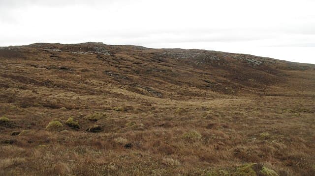
Beinn Bhragair takes its name from the crofting township of Bragar on the Atlantic coast of west Lewis, rising to 261m above the great moor inland. It is the only significant prominence between the Bragar machair and the central wilderness, giving big airy views in clear weather.
Quick facts
- Height
- 261.9m/ 859ft
- Prominence
- 151 m
- Grid ref
- NB 26684 43253
- Dogs
- Dogs on lead required near livestockDog-friendly guide ↗
Height and prominence cross-checked against the Database of British and Irish Hills (CC BY).
No GPX track yet
Walked this route? Share your track to help other walkers.
Standard route
blanket bog 55% · heather moorland 30% · rocky summit 15%
A pathless 8-10km return from the A858 near Bragar, taking 3-5 hours. The walk crosses open peatland on a gradual rise to the low summit knoll, with no real difficulties beyond the boggy ground.
Terrain
Almost entirely blanket bog, with peat hags and small lochans throughout. The summit knoll is a low gneiss outcrop. Gaiters strongly advised year-round.
In winter
Modest height and short distance make this very feasible in winter, but the moor is utterly featureless in poor visibility. A short cold spell can usefully harden the bog underfoot.
Best time of year
Getting there
- Glasgow9h 52m
- Edinburgh11h 51m
Ferry access
Ullapool → Stornoway (Lewis)
- Crossing time165 min
- Summer sailings2 sailings daily (Apr–Oct)
- Winter sailings1 sailing daily (Nov–Mar)
- Book ahead14 days
- Last ferry backCheck CalMac timetable
Allow 1–2 hours drive from Stornoway to reach the Harris hills. For South Harris hills, Uig → Tarbert may be more convenient.
Book on CalMac ↗OS maps: OS Landranger 8, OS Explorer 459W, OS Explorer 460W
Mobile signal: Poor. EE absent; bring offline maps for this trackless Lewis hill.
Current conditions
Daylight Today
- Sunrise
- 05:13
- Sunset
- 21:53
- Civil dawn
- 04:18
- Civil dusk
- 22:49
NOAA Solar Calculator · 30 July 2026
Around Beinn Bhragair on the SCOT network
Getting there, basing yourself, and what to do off the hill.
Beinn Bhragair — common questions
- Is Beinn Bhragair a hard climb?
- Beinn Bhragair is rated 1/5 (easy) on the OutdoorSCOT scale. Ground conditions: Almost entirely blanket bog, with peat hags and small lochans throughout.
- How much drop does Beinn Bhragair have?
- The drop is 151m: measured from the summit of Beinn Bhragair down to the saddle joining it to higher terrain. Passing the 150m-drop threshold on all sides is exactly what makes it a Marilyn.
- What's the best month to climb Beinn Bhragair?
- Aim for March, April, May, June, July, August, September, October on Beinn Bhragair. In the remaining months treat it as a winter hill — full kit, solid navigation, and a look at the relevant SAIS avalanche forecast before you go.
- Can dogs go up Beinn Bhragair?
- Dogs are fine on a lead. The route passes livestock or ground-nesting bird habitat, so keep them close throughout.
- Will I get phone signal on Beinn Bhragair?
- Poor. EE absent; bring offline maps for this trackless Lewis hill.
- How do I get the ferry to Beinn Bhragair?
- Ullapool → Stornoway (Lewis). 2 sailings daily (Apr–Oct) in summer; 1 sailing daily (Nov–Mar) in winter. Book at least 14 days ahead. Allow 1–2 hours drive from Stornoway to reach the Harris hills. For South Harris hills, Uig → Tarbert may be more convenient.
- Is Beinn Bhragair safe in winter?
- Modest height and short distance make this very feasible in winter, but the moor is utterly featureless in poor visibility. A short cold spell can usefully harden the bog underfoot.
Get the OutdoorSCOT weekly
One email a week — new route, hill and bothy guides, seasonal conditions and the odd hard-won lesson. No spam, unsubscribe in one click.