Marilyn · Glen Coe & Lochaber
Beinn Lora
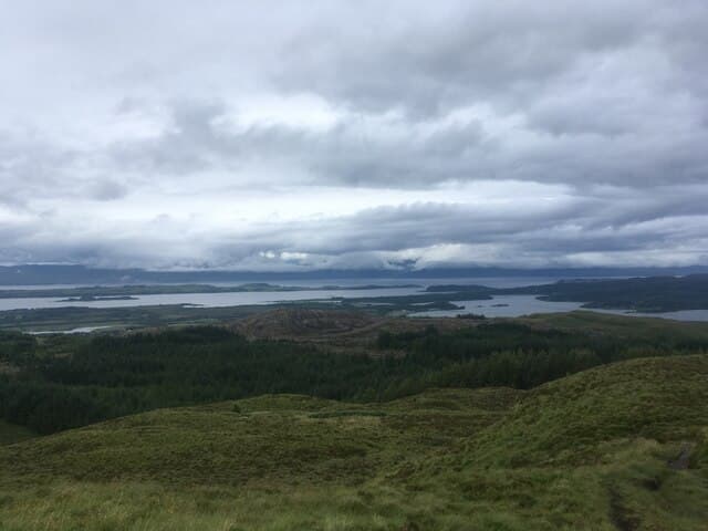
Beinn Lora is a 308m forested Marilyn in NM-square Argyll, immediately above the village of Benderloch on the A828 just north of Connel. Despite its low altitude the hill stands alone above the sea, with the trig point looking west across Ardmucknish Bay to Lismore and the Sound of Mull and east into the mouth of Loch Etive.
Quick facts
- Height
- 308m/ 1010ft
- Prominence
- 171 m
- Grid ref
- NM 91941 37736
- Nearest city
- Oban· 10km
- Dogs
- Dogs on lead required near livestockDog-friendly guide ↗
Height and prominence cross-checked against the Database of British and Irish Hills (CC BY).
No GPX track yet
Walked this route? Share your track to help other walkers.
Standard route
heather moorland 55% · grass and bracken 30% · rocky summit 15%
The standard route uses the Forestry and Land Scotland car park at the south end of Benderloch, climbing a marked path through spruce and birch onto the open heather crest. A short rocky pull leads to the trig pillar and an open viewpoint set with benches and orientation panels.
Terrain
Made path through forestry for the first kilometre, then duck-boarded heather and a stretch of cropped grass to the summit slabs. Some boggy spots remain after the boardwalk ends.
In winter
A coastal hill that almost never holds settled snow — the main winter issue is fallen branches on the forest track after gales, and slippery boardwalk timbers when iced. Headtorch essential outside summer; the woodland blocks late afternoon light.
This hill is in the Glen Coe SAIS forecast area. Check SAIS forecasts in winter (December–April).
Best time of year
Getting there
- Glasgow3h 20m
- Edinburgh6h 50m
OS maps: OS Landranger 49, OS Explorer 376
Mobile signal: Decent up top; EE reliable. Fine Loch Etive views from this accessible Argyll Marilyn.
Current conditions
Daylight Today
- Sunrise
- 05:19
- Sunset
- 21:37
- Civil dawn
- 04:28
- Civil dusk
- 22:28
NOAA Solar Calculator · 30 July 2026
Around Beinn Lora on the SCOT network
Getting there, basing yourself, and what to do off the hill.
Getting there: Oban station
Argyll ferry hub; Mull, Lismore, Coll, Tiree, Barra connections
10km from the hill
tripscot.co.uk
On TripSCOTBase yourself in Oban
Argyll ferry hub — Mull, Lismore, Coll, Tiree, Barra
10km from the hill
tripscot.co.uk
On TasteSCOTAfter the hill: Oban
Oban town centre — tiny two-still distillery bridging Highland and West Coast styles
10km from the hill
tastescot.co.uk
Beinn Lora — common questions
- Is Beinn Lora a hard climb?
- Beinn Lora is rated 1/5 (easy) on the OutdoorSCOT scale. Ground conditions: Made path through forestry for the first kilometre, then duck-boarded heather and a stretch of cropped grass to the summit slabs.
- How much drop does Beinn Lora have?
- The drop is 171m: measured from the summit of Beinn Lora down to the saddle joining it to higher terrain. Passing the 150m-drop threshold on all sides is exactly what makes it a Marilyn.
- What's the best month to climb Beinn Lora?
- Aim for March, April, May, June, July, August, September, October on Beinn Lora. In the remaining months treat it as a winter hill — full kit, solid navigation, and a look at the relevant SAIS avalanche forecast before you go.
- Can dogs go up Beinn Lora?
- Dogs are fine on a lead. The route passes livestock or ground-nesting bird habitat, so keep them close throughout.
- Will I get phone signal on Beinn Lora?
- Decent up top; EE reliable. Fine Loch Etive views from this accessible Argyll Marilyn.
- Is Beinn Lora safe in winter?
- A coastal hill that almost never holds settled snow — the main winter issue is fallen branches on the forest track after gales, and slippery boardwalk timbers when iced. Headtorch essential outside summer; the woodland blocks late afternoon light.
Get the OutdoorSCOT weekly
One email a week — new route, hill and bothy guides, seasonal conditions and the odd hard-won lesson. No spam, unsubscribe in one click.