Marilyn · Glen Coe & Lochaber
Beinn Leamhain
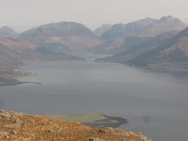
Beinn Leamhain — the Elm Hill — is a 508m hill in south Ardgour, set back from Loch Linnhe above the village of Inversanda. Few elms remain on the slopes now, but the name preserves an older landscape. The hill gives long views down Loch Linnhe to Lismore and the Firth of Lorn.
Quick facts
- Height
- 508m/ 1667ft
- Prominence
- 331 m
- Grid ref
- NM 95727 62284
- Nearest city
- Fort William· 19km
- Dogs
- Dogs on lead required near livestockDog-friendly guide ↗
Height and prominence cross-checked against the Database of British and Irish Hills (CC BY).
No GPX track yet
Walked this route? Share your track to help other walkers.
Standard route
heather and bog 60% · rocky slopes 25% · grass slopes 15%
Park near the bridge in Inversanda on the A861 and follow the burn that drains the south face, climbing steep grass to gain the broad summit ridge. The route is short, sharp and pathless. Three to four hours.
Terrain
Bracken and rough grass dominate the lower slopes; expect tussocks and small drainage channels. Higher up the terrain becomes shorter grass with occasional rock steps. No paths.
In winter
Light snow cover with frozen tussocks underneath makes the descent unexpectedly tricky. The hill is too low to give a proper winter climb but works as a short outing on cold clear days.
This hill is in the Glen Coe SAIS forecast area. Check SAIS forecasts in winter (December–April).
Best time of year
Getting there
- Glasgow4h 34m
- Edinburgh6h 54m
OS maps: OS Landranger 40, OS Explorer 391
Mobile signal: Poor. Remote Ardgour/Sunart; limited coverage.
Current conditions
Daylight Today
- Sunrise
- 05:17
- Sunset
- 21:38
- Civil dawn
- 04:26
- Civil dusk
- 22:29
NOAA Solar Calculator · 30 July 2026
Around Beinn Leamhain on the SCOT network
Getting there, basing yourself, and what to do off the hill.
Getting there: Fort William station
Ben Nevis, Mamores, Aonachs, Knoydart ferry connection
19km from the hill
tripscot.co.uk
On TripSCOTBase yourself in Fort William
Ben Nevis base, West Highland Line, gateway to Lochaber
19km from the hill
tripscot.co.uk
On TasteSCOTAfter the hill: Ben Nevis Distillery
Fort William — Lochaber distillery at the foot of the Ben; long-aged Japanese-owned classics
21km from the hill
tastescot.co.uk
Beinn Leamhain — common questions
- What difficulty is Beinn Leamhain?
- On the OutdoorSCOT scale, Beinn Leamhain comes in at 2/5 — moderate. Underfoot: Bracken and rough grass dominate the lower slopes; expect tussocks and small drainage channels.
- What is Beinn Leamhain's prominence?
- 331m of prominence. That's the vertical drop from the summit to the col that links Beinn Leamhain to the next higher ground. That drop is what qualifies it as a Marilyn — a hill with at least 150m of descent on every side.
- When is the best time to climb Beinn Leamhain?
- March, April, May, June, July, August, September, October give the most reliable conditions on Beinn Leamhain. Beyond that window the high ground turns wintry: carry full mountain kit, be confident navigating, and check the SAIS avalanche forecast for the area.
- Is Beinn Leamhain dog-friendly?
- Yes, but dogs must be kept on a lead — there is livestock or ground-nesting bird interest on the route.
- Is there mobile signal on Beinn Leamhain?
- Poor. Remote Ardgour/Sunart; limited coverage.
- Is Beinn Leamhain safe in winter?
- Light snow cover with frozen tussocks underneath makes the descent unexpectedly tricky. The hill is too low to give a proper winter climb but works as a short outing on cold clear days.
Get the OutdoorSCOT weekly
One email a week — new route, hill and bothy guides, seasonal conditions and the odd hard-won lesson. No spam, unsubscribe in one click.